Yunxi geodata
Yunxi (Sichuan) is a seat of a third-order administrative division; located in China in Asia/Shanghai (GMT+8) time zone. In our database, there are 1268 cities with bigger population. Compared to other cities in China, 56.5% of cities are located further ↓South; 88.4% of cities are located further →East and 68.5% of cities have lower elevation than Yunxi. Note1


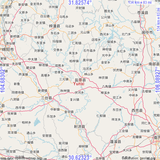
Yunxi GPS coordinates[2]
31° 13' 35.04" North, 105° 23' 10.104" East
| Map corner | latitude | longitude |
|---|---|---|
| Upper-left | 31.82574°, | 104.68302° |
| Center: | 31.2264°, | 105.38614° |
| Lower-right: | 30.62323°, | 106.08927° |
| Map W x H: | 133.7×133.7 km | = 83.1×83.1mi |
| max Lat: | 53.31946° ⇑43.5% North |
| Yunxi: | 31.2264° |
| min Lat: | ⇓56.5% South 18.22056° |
| min Long | Yunxi | max Long |
| 75.07348° | 105.38614° | 134.28917° |
| W 11.6%⇐ | ⇒88.4% E |
Elevation
Elevation of Yunxi is 386 m = 1266 ft, and this is 98.8 m = 324 ft below average elevation for this country.
| Max E: |
5622 m = 18445 ft | 31.5% |
| Avg. | 484.8 m = 1591 ft | |
| Yunxi | 386 m = 1266 ft | |
Min E: |
-3 m = -10 ft | 68.5% |
See also: China elevation on elevation.city.
Geographical zone
Yunxi is located in North temperate zone (between Tropic of Cancer and the Arctic Circle). Distance of this Northern Tropic circle is 866.1 km =538.2 mi to South.| Distance of | km | miles | from Yunxi |
|---|---|---|---|
| North Pole | 6535 | 4060.7 | to North |
| Arctic Circle | 3929.1 | 2441.4 | to North |
| Tropic Cancer | 866.1 | 538.2 | to South |
| Equator | 3472.1 | 2157.5 | to South |


Nearby cities:
15 places around Yunxi: (largest is in red/bold)
• Chicheng
58.6 km =36.4 mi,  147°
147°
• Huohua
82.6 km =51.3 mi,  129°
129°
• Jincheng
53.6 km =33.3 mi,  118°
118°
• Kaijiang
70.8 km =44 mi,  252°
252°
• Langzhong
68 km =42.3 mi,  58°
58°
• Lingjiang
76.6 km =47.6 mi,  42°
42°
• Luojiang
84.2 km =52.3 mi,  275°
275°
• Mianyang
72.1 km =44.8 mi,  291°
291°
• Nanchong
82 km =51 mi, 125°
• Nanlong
65.9 km =40.9 mi,  77°
77°
• Penglai
72.8 km =45.2 mi,  190°
190°
• Suining
81.8 km =50.8 mi,  167°
167°
• Taihe
39.5 km =24.5 mi,  180°
180°
• Tongchuan
32 km =19.9 mi,  242°
242°
• Wenchang
50.6 km =31.4 mi,  334°
334°
Sources, notices
• [Note1] Compared only with cities in China existing in our database
• [Src1] Map data: © OpenStreetMap contributors (CC-BY-SA)
• [Src2] Other city data from geonames.org with taken over terms of usage.
• [Src3] Geographical zone / Annual Mean Temperature by Robert A. Rohde @ Wikipedia
