Xia’er geodata
Xia’er (Sichuan) is a seat of a third-order administrative division; located in China in Asia/Shanghai (GMT+8) time zone. In our database, there are 1268 cities with bigger population. Compared to other cities in China, 65.4% of cities are located further ↑North; 93.4% of cities are located further →East and 97.7% of cities have lower elevation than Xia’er. Note1


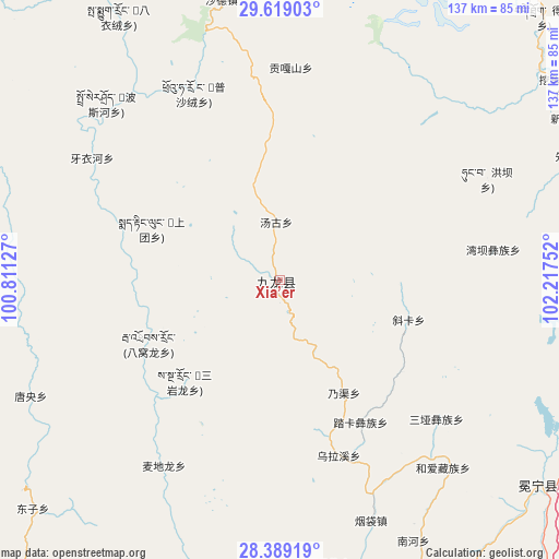
Xia’er GPS coordinates[2]
29° 0' 21.384" North, 101° 30' 51.804" East
| Map corner | latitude | longitude |
|---|---|---|
| Upper-left | 29.61903°, | 100.81127° |
| Center: | 29.00594°, | 101.51439° |
| Lower-right: | 28.38919°, | 102.21752° |
| Map W x H: | 136.7×136.7 km | = 84.9×84.9mi |
| max Lat: | 53.31946° ⇑65.4% North |
| Xia’er: | 29.00594° |
| min Lat: | ⇓34.6% South 18.22056° |
| min Long | Xia’er | max Long |
| 75.07348° | 101.51439° | 134.28917° |
| W 6.6%⇐ | ⇒93.4% E |
Elevation
Elevation of Xia’er is 3435 m = 11270 ft, and this is 2950.2 m = 9679 ft above average elevation for this country.
| Max E: |
5622 m = 18445 ft | 2.3% |
| Xia’er | 3435 m 11270 ft | |
| Avg. | 484.8 m = 1591 ft | |
Min E: |
-3 m = -10 ft | 97.7% |
See also: China elevation on elevation.city.
Geographical zone
Xia’er is located in North temperate zone (between Tropic of Cancer and the Arctic Circle). Distance of this Northern Tropic circle is 619.2 km =384.8 mi to South.| Distance of | km | miles | from Xia’er |
|---|---|---|---|
| North Pole | 6781.9 | 4214.1 | to North |
| Arctic Circle | 4176 | 2594.8 | to North |
| Tropic Cancer | 619.2 | 384.8 | to South |
| Equator | 3225.2 | 2004 | to South |


Nearby cities:
15 places around Xia’er: (largest is in red/bold)
• Chengxiang
81.2 km =50.5 mi,  128°
128°
• Gaocheng
162.6 km =101 mi,  312°
312°
• Guangming
116.8 km =72.6 mi, 131°
• Hepingyizu
154.6 km =96.1 mi,  80°
80°
• Kangding
118.8 km =73.8 mi,  21°
21°
• Luqiao
124.2 km =77.2 mi,  33°
33°
• Qiaowa
121.8 km =75.7 mi,  190°
190°
• Sangpi
167 km =103.8 mi,  267°
267°
• Shaping
172 km =106.9 mi, 81°
• Shirong
117 km =72.7 mi,  70°
70°
• Xichang
143.5 km =89.2 mi,  149°
149°
• Xincheng
170.2 km =105.8 mi, 130°
• Xinmian
87.3 km =54.2 mi, 72°
• Xinshiba
122.3 km =76 mi,  91°
91°
• Yuecheng
105 km =65.2 mi,  112°
112°
Sources, notices
• [Note1] Compared only with cities in China existing in our database
• [Src1] Map data: © OpenStreetMap contributors (CC-BY-SA)
• [Src2] Other city data from geonames.org with taken over terms of usage.
• [Src3] Geographical zone / Annual Mean Temperature by Robert A. Rohde @ Wikipedia
