Xinshiba geodata
Xinshiba (Sichuan) is a seat of a third-order administrative division; located in China in Asia/Shanghai (GMT+8) time zone. In our database, there are 1268 cities with bigger population. Compared to other cities in China, 65.7% of cities are located further ↑North; 91.9% of cities are located further →East and 86.1% of cities have lower elevation than Xinshiba. Note1


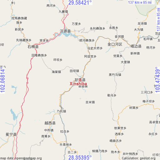
Xinshiba GPS coordinates[2]
28° 58' 15.276" North, 102° 46' 16.536" East
| Map corner | latitude | longitude |
|---|---|---|
| Upper-left | 29.58421°, | 102.06814° |
| Center: | 28.97091°, | 102.77126° |
| Lower-right: | 28.35395°, | 103.47439° |
| Map W x H: | 136.8×136.8 km | = 85×85mi |
| max Lat: | 53.31946° ⇑65.7% North |
| Xinshiba: | 28.97091° |
| min Lat: | ⇓34.3% South 18.22056° |
| min Long | Xinshiba | max Long |
| 75.07348° | 102.77126° | 134.28917° |
| W 8.1%⇐ | ⇒91.9% E |
Elevation
Elevation of Xinshiba is 1053 m = 3455 ft, and this is 568.2 m = 1864 ft above average elevation for this country.
| Max E: |
5622 m = 18445 ft | 13.9% |
| Xinshiba | 1053 m 3455 ft | |
| Avg. | 484.8 m = 1591 ft | |
Min E: |
-3 m = -10 ft | 86.1% |
See also: China elevation on elevation.city.
Geographical zone
Xinshiba is located in North temperate zone (between Tropic of Cancer and the Arctic Circle). Distance of this Northern Tropic circle is 615.3 km =382.3 mi to South.| Distance of | km | miles | from Xinshiba |
|---|---|---|---|
| North Pole | 6785.8 | 4216.5 | to North |
| Arctic Circle | 4179.9 | 2597.3 | to North |
| Tropic Cancer | 615.3 | 382.3 | to South |
| Equator | 3221.3 | 2001.6 | to South |


Nearby cities:
15 places around Xinshiba: (largest is in red/bold)
• Chengxiang
75 km =46.6 mi,  231°
231°
• Guangming
81.4 km =50.6 mi,  205°
205°
• Hepingyizu
43.1 km =26.8 mi,  44°
44°
• Jincheng
110.4 km =68.6 mi,  135°
135°
• Minjian
76.6 km =47.6 mi,  100°
100°
• Muxi
109.9 km =68.3 mi,  90°
90°
• Nan’an
114.3 km =71 mi, 37°
• Shaping
56.1 km =34.9 mi,  58°
58°
• Shawan
89.5 km =55.6 mi, 56°
• Shirong
43.8 km =27.2 mi,  344°
344°
• Suishan
99.1 km =61.6 mi, 44°
• Xincheng
106.5 km =66.2 mi,  176°
176°
• Xinmian
49 km =30.4 mi,  307°
307°
• Yucheng
114.9 km =71.4 mi,  11°
11°
• Yuecheng
44.7 km =27.8 mi, 214°
Sources, notices
• [Note1] Compared only with cities in China existing in our database
• [Src1] Map data: © OpenStreetMap contributors (CC-BY-SA)
• [Src2] Other city data from geonames.org with taken over terms of usage.
• [Src3] Geographical zone / Annual Mean Temperature by Robert A. Rohde @ Wikipedia
