Laocheng geodata
Laocheng (Shandong) is a populated place; located in China in Asia/Shanghai (GMT+8) time zone. With population of 3,922 people, there are 900 cities with bigger population in this country. Compared to other cities in China, 79.5% of cities are located further ↓South; 59.4% of cities are located further ←West and 76.7% of cities have higher elevation than Laocheng. Note1


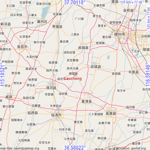
Laocheng GPS coordinates[2]
37° 8' 34.008" North, 115° 53' 17.988" East
| Map corner | latitude | longitude |
|---|---|---|
| Upper-left | 37.70118°, | 115.18521° |
| Center: | 37.14278°, | 115.88833° |
| Lower-right: | 36.58022°, | 116.59146° |
| Map W x H: | 124.6×124.6 km | = 77.4×77.4mi |
| max Lat: | 53.31946° ⇑20.5% North |
| Laocheng: | 37.14278° |
| min Lat: | ⇓79.5% South 18.22056° |
| min Long | Laocheng | max Long |
| 75.07348° | 115.88833° | 134.28917° |
| W 59.4%⇐ | ⇒40.6% E |
Elevation
Elevation of Laocheng is 33 m = 108 ft, and this is 451.8 m = 1482 ft below average elevation for this country.
| Max E: |
5622 m = 18445 ft | 76.7% |
| Avg. | 484.8 m = 1591 ft | |
| Laocheng | 33 m = 108 ft | |
Min E: |
-3 m = -10 ft | 23.3% |
See also: China elevation on elevation.city.
Geographical zone
Laocheng is located in North temperate zone (between Tropic of Cancer and the Arctic Circle). Distance of this Northern Tropic circle is 1524 km =947 mi to South.| Distance of | km | miles | from Laocheng |
|---|---|---|---|
| North Pole | 5877.2 | 3651.9 | to North |
| Arctic Circle | 3271.3 | 2032.7 | to North |
| Tropic Cancer | 1524 | 947 | to South |
| Equator | 4129.9 | 2566.2 | to South |


Nearby cities:
15 places around Laocheng: (largest is in red/bold)
• Dezhou
50.7 km =31.5 mi,  47°
47°
• Gaobeijie
36.5 km =22.7 mi,  209°
209°
• Hengshui
67.6 km =42 mi,  345°
345°
• Jiamaying
9.1 km =5.7 mi,  36°
36°
• Jingzhou
69 km =42.9 mi,  28°
28°
• Lingcheng
63.8 km =39.6 mi,  70°
70°
• Liuzhuang
18.4 km =11.4 mi, 213°
• Mingzhou
59 km =36.7 mi,  251°
251°
• Nancheng
23.7 km =14.7 mi,  155°
155°
• Nangong
51.4 km =31.9 mi,  297°
297°
• Qiangezhai
49.5 km =30.8 mi, 246°
• Qingnian
37.1 km =23.1 mi,  204°
204°
• Xiliguantun
8.6 km =5.3 mi,  146°
146°
• Xinhu
49.5 km =30.8 mi, 46°
• Youfang
18 km =11.2 mi,  215°
215°
Sources, notices
• [Note1] Compared only with cities in China existing in our database
• [Src1] Map data: © OpenStreetMap contributors (CC-BY-SA)
• [Src2] Other city data from geonames.org with taken over terms of usage.
• [Src3] Geographical zone / Annual Mean Temperature by Robert A. Rohde @ Wikipedia
