Liuzhuang geodata
Liuzhuang (Hebei) is a seat of a fourth-order administrative division; located in China in Asia/Shanghai (GMT+8) time zone. In our database, there are 1268 cities with bigger population. Compared to other cities in China, 79.2% of cities are located further ↓South; 58.7% of cities are located further ←West and 76.2% of cities have higher elevation than Liuzhuang. Note1


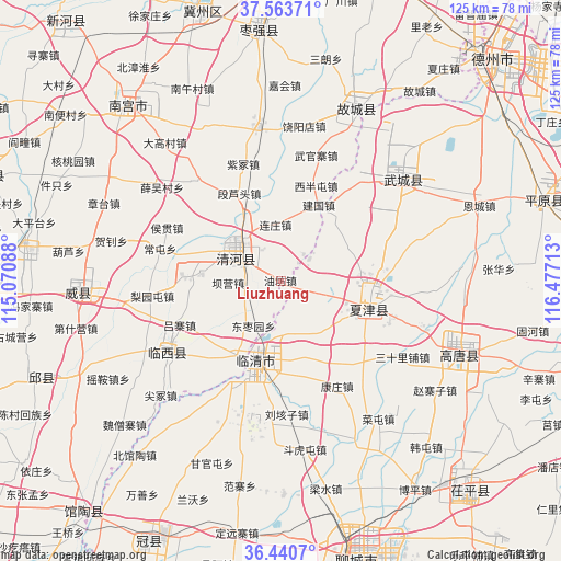
Liuzhuang GPS coordinates[2]
37° 0' 15.408" North, 115° 46' 26.4" East
| Map corner | latitude | longitude |
|---|---|---|
| Upper-left | 37.56371°, | 115.07088° |
| Center: | 37.00428°, | 115.774° |
| Lower-right: | 36.4407°, | 116.47713° |
| Map W x H: | 124.9×124.9 km | = 77.6×77.6mi |
| max Lat: | 53.31946° ⇑20.8% North |
| Liuzhuang: | 37.00428° |
| min Lat: | ⇓79.2% South 18.22056° |
| min Long | Liuzhuang | max Long |
| 75.07348° | 115.774° | 134.28917° |
| W 58.7%⇐ | ⇒41.3% E |
Elevation
Elevation of Liuzhuang is 34 m = 112 ft, and this is 450.8 m = 1479 ft below average elevation for this country.
| Max E: |
5622 m = 18445 ft | 76.2% |
| Avg. | 484.8 m = 1591 ft | |
| Liuzhuang | 34 m = 112 ft | |
Min E: |
-3 m = -10 ft | 23.8% |
See also: China elevation on elevation.city.
Geographical zone
Liuzhuang is located in North temperate zone (between Tropic of Cancer and the Arctic Circle). Distance of this Northern Tropic circle is 1508.6 km =937.4 mi to South.| Distance of | km | miles | from Liuzhuang |
|---|---|---|---|
| North Pole | 5892.6 | 3661.5 | to North |
| Arctic Circle | 3286.7 | 2042.3 | to North |
| Tropic Cancer | 1508.6 | 937.4 | to South |
| Equator | 4114.5 | 2556.6 | to South |


Nearby cities:
15 places around Liuzhuang: (largest is in red/bold)
• Chensan
64.2 km =39.9 mi,  242°
242°
• Dongliang’erzhuang
55.5 km =34.5 mi, 236°
• Dongluqiao
52.7 km =32.7 mi,  227°
227°
• Gaobeijie
18.2 km =11.3 mi,  206°
206°
• Jiamaying
27.5 km =17.1 mi,  34°
34°
• Laocheng
18.4 km =11.4 mi, 33°
• Liaocheng
63.6 km =39.5 mi,  163°
163°
• Mingzhou
46.1 km =28.6 mi,  266°
266°
• Nancheng
20.8 km =12.9 mi,  107°
107°
• Nangong
52.9 km =32.9 mi,  318°
318°
• Qiangezhai
35.4 km =22 mi,  262°
262°
• Qingnian
19 km =11.8 mi,  196°
196°
• Xiliguantun
17 km =10.6 mi,  61°
61°
• Xinmatou
57.5 km =35.7 mi,  248°
248°
• Youfang
0.9 km =0.6 mi,  334°
334°
Sources, notices
• [Note1] Compared only with cities in China existing in our database
• [Src1] Map data: © OpenStreetMap contributors (CC-BY-SA)
• [Src2] Other city data from geonames.org with taken over terms of usage.
• [Src3] Geographical zone / Annual Mean Temperature by Robert A. Rohde @ Wikipedia
