Rizhao geodata
Rizhao (Shandong) is a seat of a third-order administrative division; located in China in Asia/Shanghai (GMT+8) time zone. With population of 246,387 people, there are 203 cities with bigger population in this country. Compared to other cities in China, 75.8% of cities are located further ↓South; 78.5% of cities are located further ←West and 84.9% of cities have higher elevation than Rizhao. Note1


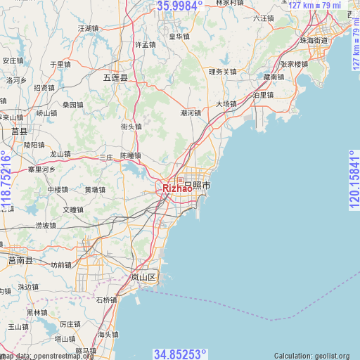
Rizhao GPS coordinates[2]
35° 25' 39" North, 119° 27' 19.008" East
| Map corner | latitude | longitude |
|---|---|---|
| Upper-left | 35.9984°, | 118.75216° |
| Center: | 35.4275°, | 119.45528° |
| Lower-right: | 34.85253°, | 120.15841° |
| Map W x H: | 127.4×127.4 km | = 79.2×79.2mi |
| max Lat: | 53.31946° ⇑24.2% North |
| Rizhao: | 35.4275° |
| min Lat: | ⇓75.8% South 18.22056° |
| min Long | Rizhao | max Long |
| 75.07348° | 119.45528° | 134.28917° |
| W 78.5%⇐ | ⇒21.5% E |
Elevation
Elevation of Rizhao is 16 m = 52 ft, and this is 468.8 m = 1538 ft below average elevation for this country.
| Max E: |
5622 m = 18445 ft | 84.9% |
| Avg. | 484.8 m = 1591 ft | |
| Rizhao | 16 m = 52 ft | |
Min E: |
-3 m = -10 ft | 15.1% |
See also: Rizhao elevation on elevation.city.
Geographical zone
Rizhao is located in North temperate zone (between Tropic of Cancer and the Arctic Circle). Distance of this Northern Tropic circle is 1333.2 km =828.4 mi to South.| Distance of | km | miles | from Rizhao |
|---|---|---|---|
| North Pole | 6067.9 | 3770.4 | to North |
| Arctic Circle | 3462 | 2151.2 | to North |
| Tropic Cancer | 1333.2 | 828.4 | to South |
| Equator | 3939.2 | 2447.7 | to South |


Nearby cities:
15 places around Rizhao: (largest is in red/bold)
• Andongwei
36.9 km =22.9 mi,  206°
206°
• Chaoyang
84.1 km =52.3 mi,  189°
189°
• Chengyang
58.8 km =36.5 mi,  286°
286°
• Gaogongdao
81.4 km =50.6 mi,  178°
178°
• Haitou
60.7 km =37.7 mi, 205°
• Lianyun
77.3 km =48 mi, 180°
• Mizhou
63.3 km =39.3 mi,  355°
355°
• Qingkou
71.7 km =44.6 mi, 206°
• Rizhao
7.8 km =4.8 mi,  116°
116°
• Shizilu
63.6 km =39.5 mi,  243°
243°
• Songzhuang
77.1 km =47.9 mi,  201°
201°
• Yinzhu
68.7 km =42.7 mi,  43°
43°
• Yishui
84.7 km =52.6 mi,  297°
297°
• Yunshan
81.3 km =50.5 mi, 185°
• Zhu Cheng City
63.3 km =39.3 mi, 355°
Sources, notices
• [Note1] Compared only with cities in China existing in our database
• [Src1] Map data: © OpenStreetMap contributors (CC-BY-SA)
• [Src2] Other city data from geonames.org with taken over terms of usage.
• [Src3] Geographical zone / Annual Mean Temperature by Robert A. Rohde @ Wikipedia
