Feicheng geodata
Feicheng (Shandong) is a populated place; located in China in Asia/Shanghai (GMT+8) time zone. With population of 77,606 people, there are 550 cities with bigger population in this country. Compared to other cities in China, 77.7% of cities are located further ↓South; 64.7% of cities are located further ←West and 57.4% of cities have higher elevation than Feicheng. Note1


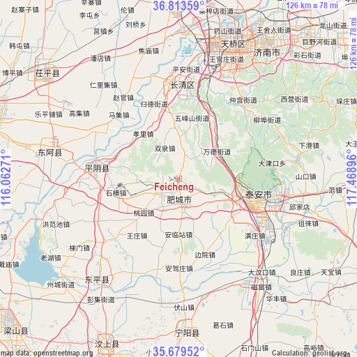
Feicheng GPS coordinates[2]
36° 14' 54.996" North, 116° 45' 56.988" East
| Map corner | latitude | longitude |
|---|---|---|
| Upper-left | 36.81359°, | 116.06271° |
| Center: | 36.24861°, | 116.76583° |
| Lower-right: | 35.67952°, | 117.46896° |
| Map W x H: | 126.1×126.1 km | = 78.4×78.4mi |
| max Lat: | 53.31946° ⇑22.3% North |
| Feicheng: | 36.24861° |
| min Lat: | ⇓77.7% South 18.22056° |
| min Long | Feicheng | max Long |
| 75.07348° | 116.76583° | 134.28917° |
| W 64.7%⇐ | ⇒35.3% E |
Elevation
Elevation of Feicheng is 115 m = 377 ft, and this is 369.8 m = 1213 ft below average elevation for this country.
| Max E: |
5622 m = 18445 ft | 57.4% |
| Avg. | 484.8 m = 1591 ft | |
| Feicheng | 115 m = 377 ft | |
Min E: |
-3 m = -10 ft | 42.6% |
See also: Feicheng elevation on elevation.city.
Geographical zone
Feicheng is located in North temperate zone (between Tropic of Cancer and the Arctic Circle). Distance of this Northern Tropic circle is 1424.5 km =885.1 mi to South.| Distance of | km | miles | from Feicheng |
|---|---|---|---|
| North Pole | 5976.6 | 3713.7 | to North |
| Arctic Circle | 3370.7 | 2094.5 | to North |
| Tropic Cancer | 1424.5 | 885.1 | to South |
| Equator | 4030.5 | 2504.4 | to South |


Nearby cities:
15 places around Feicheng: (largest is in red/bold)
• Changqing
34.5 km =21.4 mi,  354°
354°
• Gulou
75 km =46.6 mi,  286°
286°
• Jinan
51.1 km =31.8 mi,  23°
23°
• Laiwu
80.2 km =49.8 mi,  94°
94°
• Liaocheng
74.3 km =46.2 mi, 288°
• Lingcheng
80.6 km =50.1 mi,  170°
170°
• Ningyang
53.9 km =33.5 mi,  177°
177°
• Pingyin
29 km =18 mi,  277°
277°
• Qufu
75.3 km =46.8 mi,  164°
164°
• Sishui
81 km =50.3 mi,  145°
145°
• Tai’an
32.5 km =20.2 mi,  102°
102°
• Wenshang
62.8 km =39 mi,  202°
202°
• Yancheng
61.3 km =38.1 mi,  358°
358°
• Yanzhou
77.6 km =48.2 mi, 175°
• Zhoucheng
55.4 km =34.4 mi,  227°
227°
Sources, notices
• [Note1] Compared only with cities in China existing in our database
• [Src1] Map data: © OpenStreetMap contributors (CC-BY-SA)
• [Src2] Other city data from geonames.org with taken over terms of usage.
• [Src3] Geographical zone / Annual Mean Temperature by Robert A. Rohde @ Wikipedia
