Guiyang geodata
Guiyang (Guizhou) is a seat of a first-order administrative division; located in China in Asia/Shanghai (GMT+8) time zone. With population of 1,171,633 people, there are 58 cities with bigger population in this country. Compared to other cities in China, 80.1% of cities are located further ↑North; 84.5% of cities are located further →East and 86.6% of cities have lower elevation than Guiyang. Note1


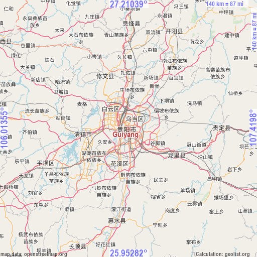
Guiyang GPS coordinates[2]
26° 34' 59.988" North, 106° 43' 0.012" East
| Map corner | latitude | longitude |
|---|---|---|
| Upper-left | 27.21039°, | 106.01355° |
| Center: | 26.58333°, | 106.71667° |
| Lower-right: | 25.95282°, | 107.4198° |
| Map W x H: | 139.8×139.8 km | = 86.9×86.9mi |
| max Lat: | 53.31946° ⇑80.1% North |
| Guiyang: | 26.58333° |
| min Lat: | ⇓19.9% South 18.22056° |
| min Long | Guiyang | max Long |
| 75.07348° | 106.71667° | 134.28917° |
| W 15.5%⇐ | ⇒84.5% E |
Elevation
Elevation of Guiyang is 1087 m = 3566 ft, and this is 602.2 m = 1976 ft above average elevation for this country.
| Max E: |
5622 m = 18445 ft | 13.4% |
| Guiyang | 1087 m 3566 ft | |
| Avg. | 484.8 m = 1591 ft | |
Min E: |
-3 m = -10 ft | 86.6% |
See also: Guiyang elevation on elevation.city.
Geographical zone
Guiyang is located in North temperate zone (between Tropic of Cancer and the Arctic Circle). Distance of this Northern Tropic circle is 349.9 km =217.4 mi to South.| Distance of | km | miles | from Guiyang |
|---|---|---|---|
| North Pole | 7051.3 | 4381.5 | to North |
| Arctic Circle | 4445.4 | 2762.2 | to North |
| Tropic Cancer | 349.9 | 217.4 | to South |
| Equator | 2955.8 | 1836.6 | to South |


Nearby cities:
15 places around Guiyang: (largest is in red/bold)
• Anshun
86.4 km =53.7 mi,  244°
244°
• Bijie
162.7 km =101.1 mi,  299°
299°
• Daba
161.8 km =100.5 mi,  349°
349°
• Duyun
87.1 km =54.1 mi,  113°
113°
• Guancang
161.5 km =100.4 mi,  359°
359°
• Hema
166.3 km =103.3 mi, 346°
• Renhuai
137.9 km =85.7 mi, 346°
• Shangjiang
155.9 km =96.9 mi,  117°
117°
• Supu
58.7 km =36.5 mi,  320°
320°
• Xiaoweizhai
90.5 km =56.2 mi, 118°
• Yongxi
167.2 km =103.9 mi,  73°
73°
• Zhijin
94.8 km =58.9 mi,  275°
275°
• Zhongshan
66.6 km =41.4 mi,  311°
311°
• Zhuchang
160.8 km =99.9 mi, 278°
• Zunyi
124.1 km =77.1 mi,  8°
8°
Sources, notices
• [Note1] Compared only with cities in China existing in our database
• [Src1] Map data: © OpenStreetMap contributors (CC-BY-SA)
• [Src2] Other city data from geonames.org with taken over terms of usage.
• [Src3] Geographical zone / Annual Mean Temperature by Robert A. Rohde @ Wikipedia
