Supu geodata
Supu (Guizhou) is a seat of a fourth-order administrative division; located in China in Asia/Shanghai (GMT+8) time zone. In our database, there are 1268 cities with bigger population. Compared to other cities in China, 78.6% of cities are located further ↑North; 85.7% of cities are located further →East and 88.6% of cities have lower elevation than Supu. Note1


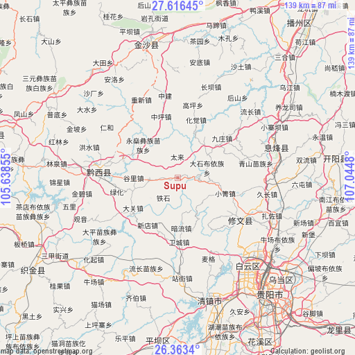
Supu GPS coordinates[2]
26° 59' 30.012" North, 106° 20' 30.012" East
| Map corner | latitude | longitude |
|---|---|---|
| Upper-left | 27.61645°, | 105.63855° |
| Center: | 26.99167°, | 106.34167° |
| Lower-right: | 26.3634°, | 107.0448° |
| Map W x H: | 139.3×139.3 km | = 86.6×86.6mi |
| max Lat: | 53.31946° ⇑78.6% North |
| Supu: | 26.99167° |
| min Lat: | ⇓21.4% South 18.22056° |
| min Long | Supu | max Long |
| 75.07348° | 106.34167° | 134.28917° |
| W 14.3%⇐ | ⇒85.7% E |
Elevation
Elevation of Supu is 1235 m = 4052 ft, and this is 750.2 m = 2461 ft above average elevation for this country.
| Max E: |
5622 m = 18445 ft | 11.4% |
| Supu | 1235 m 4052 ft | |
| Avg. | 484.8 m = 1591 ft | |
Min E: |
-3 m = -10 ft | 88.6% |
See also: China elevation on elevation.city.
Geographical zone
Supu is located in North temperate zone (between Tropic of Cancer and the Arctic Circle). Distance of this Northern Tropic circle is 395.3 km =245.6 mi to South.| Distance of | km | miles | from Supu |
|---|---|---|---|
| North Pole | 7005.9 | 4353.3 | to North |
| Arctic Circle | 4400 | 2734 | to North |
| Tropic Cancer | 395.3 | 245.6 | to South |
| Equator | 3001.2 | 1864.9 | to South |


Nearby cities:
15 places around Supu: (largest is in red/bold)
• Anshun
91.9 km =57.1 mi,  206°
206°
• Bijie
110 km =68.4 mi,  288°
288°
• Daba
114.2 km =71 mi,  4°
4°
• Dacun
116 km =72.1 mi,  350°
350°
• Guancang
121.8 km =75.7 mi,  17°
17°
• Guiyang
58.7 km =36.5 mi,  140°
140°
• Hema
116.4 km =72.3 mi,  359°
359°
• Huaqiu
127.7 km =79.3 mi,  11°
11°
• Renhuai
89.1 km =55.4 mi, 3°
• Sanhe
119.8 km =74.4 mi, 0°
• Shatan
124.5 km =77.4 mi, 356°
• Zhijin
67.4 km =41.9 mi,  237°
237°
• Zhongshan
12.4 km =7.7 mi,  265°
265°
• Zhuchang
123.3 km =76.6 mi,  260°
260°
• Zunyi
95.4 km =59.3 mi,  35°
35°
Sources, notices
• [Note1] Compared only with cities in China existing in our database
• [Src1] Map data: © OpenStreetMap contributors (CC-BY-SA)
• [Src2] Other city data from geonames.org with taken over terms of usage.
• [Src3] Geographical zone / Annual Mean Temperature by Robert A. Rohde @ Wikipedia
