Feicheng geodata
Feicheng (Shandong) is a populated place; located in China in Asia/Shanghai (GMT+8) time zone. With population of 80,929 people, there are 526 cities with bigger population in this country. Compared to other cities in China, 75.6% of cities are located further ↓South; 70.5% of cities are located further ←West and 57.5% of cities have higher elevation than Feicheng. Note1


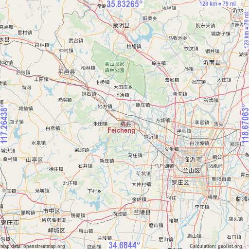
Feicheng GPS coordinates[2]
35° 15' 38.016" North, 117° 58' 3" East
| Map corner | latitude | longitude |
|---|---|---|
| Upper-left | 35.83265°, | 117.26438° |
| Center: | 35.26056°, | 117.9675° |
| Lower-right: | 34.6844°, | 118.67063° |
| Map W x H: | 127.7×127.7 km | = 79.3×79.3mi |
| max Lat: | 53.31946° ⇑24.4% North |
| Feicheng: | 35.26056° |
| min Lat: | ⇓75.6% South 18.22056° |
| min Long | Feicheng | max Long |
| 75.07348° | 117.9675° | 134.28917° |
| W 70.5%⇐ | ⇒29.5% E |
Elevation
Elevation of Feicheng is 114 m = 374 ft, and this is 370.8 m = 1217 ft below average elevation for this country.
| Max E: |
5622 m = 18445 ft | 57.5% |
| Avg. | 484.8 m = 1591 ft | |
| Feicheng | 114 m = 374 ft | |
Min E: |
-3 m = -10 ft | 42.5% |
See also: Feicheng elevation on elevation.city.
Geographical zone
Feicheng is located in North temperate zone (between Tropic of Cancer and the Arctic Circle). Distance of this Northern Tropic circle is 1314.7 km =816.9 mi to South.| Distance of | km | miles | from Feicheng |
|---|---|---|---|
| North Pole | 6086.5 | 3782 | to North |
| Arctic Circle | 3480.6 | 2162.7 | to North |
| Tropic Cancer | 1314.7 | 816.9 | to South |
| Equator | 3920.6 | 2436.1 | to South |


Nearby cities:
15 places around Feicheng: (largest is in red/bold)
• Bianzhuang
46.3 km =28.8 mi,  171°
171°
• Chengtangcun
73.3 km =45.5 mi,  254°
254°
• Dongdu
69.9 km =43.4 mi,  339°
339°
• Jiehu
54.2 km =33.7 mi,  54°
54°
• Linyi
40.6 km =25.2 mi,  122°
122°
• Mengyin
49.8 km =30.9 mi,  355°
355°
• Pingyi
40.5 km =25.2 mi,  311°
311°
• Shanting
50.7 km =31.5 mi, 246°
• Shizilu
78.9 km =49 mi,  97°
97°
• Sishui
76.1 km =47.3 mi,  304°
304°
• Tancheng
79.3 km =49.3 mi,  154°
154°
• Taozhuang
73.6 km =45.7 mi,  231°
231°
• Xiazhuang
72.1 km =44.8 mi, 122°
• Xintai
73.8 km =45.9 mi, 344°
• Zaozhuang
57.9 km =36 mi,  220°
220°
Sources, notices
• [Note1] Compared only with cities in China existing in our database
• [Src1] Map data: © OpenStreetMap contributors (CC-BY-SA)
• [Src2] Other city data from geonames.org with taken over terms of usage.
• [Src3] Geographical zone / Annual Mean Temperature by Robert A. Rohde @ Wikipedia
