Yantongshan geodata
Yantongshan (Jilin) is a populated place; located in China in Asia/Shanghai (GMT+8) time zone. With population of 57,515 people, there are 763 cities with bigger population in this country. Compared to other cities in China, 92.2% of cities are located further ↓South; 95.5% of cities are located further ←West and 59.2% of cities have lower elevation than Yantongshan. Note1


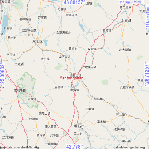
Yantongshan GPS coordinates[2]
43° 17' 30.984" North, 126° 0' 33.984" East
| Map corner | latitude | longitude |
|---|---|---|
| Upper-left | 43.80157°, | 125.30632° |
| Center: | 43.29194°, | 126.00944° |
| Lower-right: | 42.778°, | 126.71257° |
| Map W x H: | 113.8×113.8 km | = 70.7×70.7mi |
| max Lat: | 53.31946° ⇑7.8% North |
| Yantongshan: | 43.29194° |
| min Lat: | ⇓92.2% South 18.22056° |
| min Long | Yantongshan | max Long |
| 75.07348° | 126.00944° | 134.28917° |
| W 95.5%⇐ | ⇒4.5% E |
Elevation
Elevation of Yantongshan is 250 m = 820 ft, and this is 234.8 m = 770 ft below average elevation for this country.
| Max E: |
5622 m = 18445 ft | 40.8% |
| Avg. | 484.8 m = 1591 ft | |
| Yantongshan | 250 m = 820 ft | |
Min E: |
-3 m = -10 ft | 59.2% |
See also: Yantongshan elevation on elevation.city.
Geographical zone
Yantongshan is located in North temperate zone (between Tropic of Cancer and the Arctic Circle). Distance of this Northern Tropic circle is 2207.7 km =1371.8 mi to South.| Distance of | km | miles | from Yantongshan |
|---|---|---|---|
| North Pole | 5193.4 | 3227 | to North |
| Arctic Circle | 2587.6 | 1607.9 | to North |
| Tropic Cancer | 2207.7 | 1371.8 | to South |
| Equator | 4813.6 | 2991 | to South |


Nearby cities:
15 places around Yantongshan: (largest is in red/bold)
• Changchun
85.6 km =53.2 mi,  319°
319°
• Chaoyang
70 km =43.5 mi,  178°
178°
• Dongfeng
83 km =51.6 mi,  209°
209°
• Gongji
78.5 km =48.8 mi,  114°
114°
• Huadian
70.2 km =43.6 mi,  121°
121°
• Huinan
77.2 km =48 mi,  164°
164°
• Jilin
76.4 km =47.5 mi,  35°
35°
• Jiujianfang
77.7 km =48.3 mi, 117°
• Kouqian
52.9 km =32.9 mi, 43°
• Liaoyuan
83 km =51.6 mi,  238°
238°
• Meihekou
89.3 km =55.5 mi,  197°
197°
• Panshi
39.1 km =24.3 mi,  174°
174°
• Shuangyang
37.5 km =23.3 mi,  313°
313°
• Xinglongshan
85.8 km =53.3 mi,  329°
329°
• Yitong
57.7 km =35.9 mi,  273°
273°
Sources, notices
• [Note1] Compared only with cities in China existing in our database
• [Src1] Map data: © OpenStreetMap contributors (CC-BY-SA)
• [Src2] Other city data from geonames.org with taken over terms of usage.
• [Src3] Geographical zone / Annual Mean Temperature by Robert A. Rohde @ Wikipedia
