Gartog geodata
Gartog (Tibet) is a seat of a third-order administrative division; located in China in Asia/Shanghai (GMT+8) time zone. In our database, there are 1268 cities with bigger population. Compared to other cities in China, 57.7% of cities are located further ↑North; 95.3% of cities are located further →East and 98.3% of cities have lower elevation than Gartog. Note1


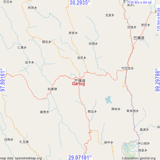
Gartog GPS coordinates[2]
29° 41' 4.236" North, 98° 35' 41.028" East
| Map corner | latitude | longitude |
|---|---|---|
| Upper-left | 30.2935°, | 97.89161° |
| Center: | 29.68451°, | 98.59473° |
| Lower-right: | 29.07181°, | 99.29786° |
| Map W x H: | 135.8×135.8 km | = 84.4×84.4mi |
| max Lat: | 53.31946° ⇑57.7% North |
| Gartog: | 29.68451° |
| min Lat: | ⇓42.3% South 18.22056° |
| min Long | Gartog | max Long |
| 75.07348° | 98.59473° | 134.28917° |
| W 4.7%⇐ | ⇒95.3% E |
Elevation
Elevation of Gartog is 3867 m = 12687 ft, and this is 3382.2 m = 11096 ft above average elevation for this country.
| Max E: |
5622 m = 18445 ft | 1.7% |
| Gartog | 3867 m 12687 ft | |
| Avg. | 484.8 m = 1591 ft | |
Min E: |
-3 m = -10 ft | 98.3% |
See also: China elevation on elevation.city.
Geographical zone
Gartog is located in North temperate zone (between Tropic of Cancer and the Arctic Circle). Distance of this Northern Tropic circle is 694.7 km =431.7 mi to South.| Distance of | km | miles | from Gartog |
|---|---|---|---|
| North Pole | 6706.5 | 4167.2 | to North |
| Arctic Circle | 4100.6 | 2548 | to North |
| Tropic Cancer | 694.7 | 431.7 | to South |
| Equator | 3300.6 | 2050.9 | to South |


Nearby cities:
15 places around Gartog: (largest is in red/bold)
• Baima
166.9 km =103.7 mi,  284°
284°
• Baiyu
161.6 km =100.4 mi,  139°
139°
• Foshan
107.7 km =66.9 mi,  169°
169°
• Gaocheng
165 km =102.5 mi,  78°
78°
• Gyigang
154.1 km =95.8 mi,  222°
222°
• Molo
134.3 km =83.5 mi,  346°
346°
• Moluo
133.2 km =82.8 mi,  339°
339°
• Sangpi
143.6 km =89.2 mi,  125°
125°
• Shengping
136.8 km =85 mi, 167°
• Songmai
127 km =78.9 mi,  148°
148°
• Wangda
73.2 km =45.5 mi,  269°
269°
• Yanduo
146.1 km =90.8 mi,  317°
317°
• Yangla
97.4 km =60.5 mi, 147°
• Yunling
159 km =98.8 mi, 166°
• Zhowagoin
159.2 km =98.9 mi, 224°
Sources, notices
• [Note1] Compared only with cities in China existing in our database
• [Src1] Map data: © OpenStreetMap contributors (CC-BY-SA)
• [Src2] Other city data from geonames.org with taken over terms of usage.
• [Src3] Geographical zone / Annual Mean Temperature by Robert A. Rohde @ Wikipedia
