Sangpi geodata
Sangpi (Sichuan) is a seat of a third-order administrative division; located in China in Asia/Shanghai (GMT+8) time zone. In our database, there are 1268 cities with bigger population. Compared to other cities in China, 66% of cities are located further ↑North; 94.7% of cities are located further →East and 96.6% of cities have lower elevation than Sangpi. Note1


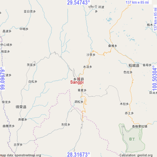
Sangpi GPS coordinates[2]
28° 56' 2.076" North, 99° 47' 59.676" East
| Map corner | latitude | longitude |
|---|---|---|
| Upper-left | 29.54743°, | 99.09679° |
| Center: | 28.93391°, | 99.79991° |
| Lower-right: | 28.31673°, | 100.50304° |
| Map W x H: | 136.8×136.8 km | = 85×85mi |
| max Lat: | 53.31946° ⇑66% North |
| Sangpi: | 28.93391° |
| min Lat: | ⇓34% South 18.22056° |
| min Long | Sangpi | max Long |
| 75.07348° | 99.79991° | 134.28917° |
| W 5.3%⇐ | ⇒94.7% E |
Elevation
Elevation of Sangpi is 2888 m = 9475 ft, and this is 2403.2 m = 7885 ft above average elevation for this country.
| Max E: |
5622 m = 18445 ft | 3.4% |
| Sangpi | 2888 m 9475 ft | |
| Avg. | 484.8 m = 1591 ft | |
Min E: |
-3 m = -10 ft | 96.6% |
See also: China elevation on elevation.city.
Geographical zone
Sangpi is located in North temperate zone (between Tropic of Cancer and the Arctic Circle). Distance of this Northern Tropic circle is 611.2 km =379.8 mi to South.| Distance of | km | miles | from Sangpi |
|---|---|---|---|
| North Pole | 6789.9 | 4219 | to North |
| Arctic Circle | 4184 | 2599.8 | to North |
| Tropic Cancer | 611.2 | 379.8 | to South |
| Equator | 3217.1 | 1999 | to South |


Nearby cities:
15 places around Sangpi: (largest is in red/bold)
• Baiyu
41.6 km =25.8 mi,  197°
197°
• Bengshutang
103.8 km =64.5 mi, 195°
• Benzilan
88.3 km =54.9 mi,  208°
208°
• Dongwang
41.8 km =26 mi,  187°
187°
• Foshan
99.3 km =61.7 mi,  257°
257°
• Gaocheng
125.7 km =78.1 mi,  21°
21°
• Gezan
81.2 km =50.5 mi,  179°
179°
• Jiantang
123.6 km =76.8 mi, 181°
• Lazanzhong
79.5 km =49.4 mi, 184°
• Shangri-La
123.6 km =76.8 mi, 184°
• Shengping
100 km =62.1 mi,  240°
240°
• Songmai
55.7 km =34.6 mi, 244°
• Yangla
65.4 km =40.6 mi,  270°
270°
• Yanmen
122.2 km =75.9 mi,  218°
218°
• Yunling
107.8 km =67 mi,  228°
228°
Sources, notices
• [Note1] Compared only with cities in China existing in our database
• [Src1] Map data: © OpenStreetMap contributors (CC-BY-SA)
• [Src2] Other city data from geonames.org with taken over terms of usage.
• [Src3] Geographical zone / Annual Mean Temperature by Robert A. Rohde @ Wikipedia
