Zhugkyung geodata
Zhugkyung (Qinghai) is a seat of a fourth-order administrative division; located in China in Asia/Shanghai (GMT+8) time zone. In our database, there are 1268 cities with bigger population. Compared to other cities in China, 80.4% of cities are located further ↓South; 94.9% of cities are located further →East and 98.3% of cities have lower elevation than Zhugkyung. Note1


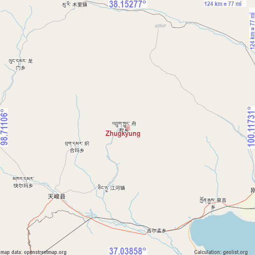
Zhugkyung GPS coordinates[2]
37° 35' 51.936" North, 99° 24' 51.048" East
| Map corner | latitude | longitude |
|---|---|---|
| Upper-left | 38.15277°, | 98.71106° |
| Center: | 37.59776°, | 99.41418° |
| Lower-right: | 37.03858°, | 100.11731° |
| Map W x H: | 123.9×123.9 km | = 77×77mi |
| max Lat: | 53.31946° ⇑19.6% North |
| Zhugkyung: | 37.59776° |
| min Lat: | ⇓80.4% South 18.22056° |
| min Long | Zhugkyung | max Long |
| 75.07348° | 99.41418° | 134.28917° |
| W 5.1%⇐ | ⇒94.9% E |
Elevation
Elevation of Zhugkyung is 3834 m = 12579 ft, and this is 3349.2 m = 10988 ft above average elevation for this country.
| Max E: |
5622 m = 18445 ft | 1.7% |
| Zhugkyung | 3834 m 12579 ft | |
| Avg. | 484.8 m = 1591 ft | |
Min E: |
-3 m = -10 ft | 98.3% |
See also: China elevation on elevation.city.
Geographical zone
Zhugkyung is located in North temperate zone (between Tropic of Cancer and the Arctic Circle). Distance of this Northern Tropic circle is 1574.6 km =978.4 mi to South.| Distance of | km | miles | from Zhugkyung |
|---|---|---|---|
| North Pole | 5826.6 | 3620.5 | to North |
| Arctic Circle | 3220.7 | 2001.2 | to North |
| Tropic Cancer | 1574.6 | 978.4 | to South |
| Equator | 4180.5 | 2597.6 | to South |


Nearby cities:
15 places around Zhugkyung: (largest is in red/bold)
• Chaka
94.5 km =58.7 mi,  198°
198°
• Hairag
97.8 km =60.8 mi,  115°
115°
• Jirmeng
51.5 km =32 mi,  164°
164°
• Karmar
57.3 km =35.6 mi,  242°
242°
• Kekeli
87.8 km =54.6 mi,  354°
354°
• Longmen
53.2 km =33.1 mi,  305°
305°
• Muri
66.9 km =41.6 mi,  332°
332°
• Qiecha
69 km =42.9 mi,  166°
166°
• Qilian
97.2 km =60.4 mi,  48°
48°
• Shaliuhe
70.4 km =43.7 mi, 115°
• Shinaihai
71 km =44.1 mi, 164°
• Xinyuan
49.3 km =30.6 mi,  227°
227°
• Yangkang
59.2 km =36.8 mi,  279°
279°
• Yeniugou
92.7 km =57.6 mi,  5°
5°
• Zamashi
85.6 km =53.2 mi,  38°
38°
Sources, notices
• [Note1] Compared only with cities in China existing in our database
• [Src1] Map data: © OpenStreetMap contributors (CC-BY-SA)
• [Src2] Other city data from geonames.org with taken over terms of usage.
• [Src3] Geographical zone / Annual Mean Temperature by Robert A. Rohde @ Wikipedia
