Lingti geodata
Lingti (Tibet) is a seat of a fourth-order administrative division; located in China in Asia/Shanghai (GMT+8) time zone. In our database, there are 1268 cities with bigger population. Compared to other cities in China, 54.5% of cities are located further ↓South; 96.7% of cities are located further →East and 99.9% of cities have lower elevation than Lingti. Note1


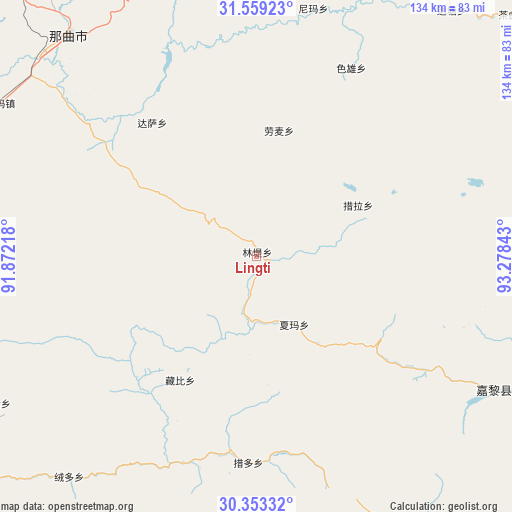
Lingti GPS coordinates[2]
30° 57' 29.448" North, 92° 34' 31.08" East
| Map corner | latitude | longitude |
|---|---|---|
| Upper-left | 31.55923°, | 91.87218° |
| Center: | 30.95818°, | 92.5753° |
| Lower-right: | 30.35332°, | 93.27843° |
| Map W x H: | 134.1×134.1 km | = 83.3×83.3mi |
| max Lat: | 53.31946° ⇑45.5% North |
| Lingti: | 30.95818° |
| min Lat: | ⇓54.5% South 18.22056° |
| min Long | Lingti | max Long |
| 75.07348° | 92.5753° | 134.28917° |
| W 3.3%⇐ | ⇒96.7% E |
Elevation
Elevation of Lingti is 4759 m = 15614 ft, and this is 4274.2 m = 14023 ft above average elevation for this country.
| Max E: |
5622 m = 18445 ft | 0.099999999999994% |
| Lingti | 4759 m 15614 ft | |
| Avg. | 484.8 m = 1591 ft | |
Min E: |
-3 m = -10 ft | 99.9% |
See also: China elevation on elevation.city.
Geographical zone
Lingti is located in North temperate zone (between Tropic of Cancer and the Arctic Circle). Distance of this Northern Tropic circle is 836.3 km =519.7 mi to South.| Distance of | km | miles | from Lingti |
|---|---|---|---|
| North Pole | 6564.8 | 4079.2 | to North |
| Arctic Circle | 3958.9 | 2459.9 | to North |
| Tropic Cancer | 836.3 | 519.7 | to South |
| Equator | 3442.2 | 2138.9 | to South |


Nearby cities:
15 places around Lingti: (largest is in red/bold)
• Arza
72.6 km =45.1 mi,  118°
118°
• Codoi
55.1 km =34.2 mi,  195°
195°
• Cola
30.3 km =18.8 mi,  63°
63°
• Dagsar
44.4 km =27.6 mi,  322°
322°
• Goqung
77.5 km =48.2 mi,  99°
99°
• Lhari
76.6 km =47.6 mi,  108°
108°
• Lomai
33.5 km =20.8 mi,  9°
9°
• Nagqu
73.6 km =45.7 mi,  312°
312°
• Nagqu
75.8 km =47.1 mi, 319°
• Nyima
66.8 km =41.5 mi, 12°
• Rongdoi
76.4 km =47.5 mi,  221°
221°
• Sexiong
55 km =34.2 mi,  26°
26°
• Xarma
20.5 km =12.7 mi,  150°
150°
• Yoiqag
78.5 km =48.8 mi,  240°
240°
• Zangbi
38.1 km =23.7 mi,  211°
211°
Sources, notices
• [Note1] Compared only with cities in China existing in our database
• [Src1] Map data: © OpenStreetMap contributors (CC-BY-SA)
• [Src2] Other city data from geonames.org with taken over terms of usage.
• [Src3] Geographical zone / Annual Mean Temperature by Robert A. Rohde @ Wikipedia
