Zangbi geodata
Zangbi (Tibet) is a seat of a fourth-order administrative division; located in China in Asia/Shanghai (GMT+8) time zone. In our database, there are 1268 cities with bigger population. Compared to other cities in China, 51.8% of cities are located further ↓South; 96.7% of cities are located further →East and 99.8% of cities have lower elevation than Zangbi. Note1


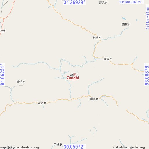
Zangbi GPS coordinates[2]
30° 39' 59.04" North, 92° 21' 56.268" East
| Map corner | latitude | longitude |
|---|---|---|
| Upper-left | 31.26929°, | 91.66251° |
| Center: | 30.6664°, | 92.36563° |
| Lower-right: | 30.05972°, | 93.06876° |
| Map W x H: | 134.5×134.5 km | = 83.6×83.6mi |
| max Lat: | 53.31946° ⇑48.2% North |
| Zangbi: | 30.6664° |
| min Lat: | ⇓51.8% South 18.22056° |
| min Long | Zangbi | max Long |
| 75.07348° | 92.36563° | 134.28917° |
| W 3.3%⇐ | ⇒96.7% E |
Elevation
Elevation of Zangbi is 4664 m = 15302 ft, and this is 4179.2 m = 13711 ft above average elevation for this country.
| Max E: |
5622 m = 18445 ft | 0.2% |
| Zangbi | 4664 m 15302 ft | |
| Avg. | 484.8 m = 1591 ft | |
Min E: |
-3 m = -10 ft | 99.8% |
See also: China elevation on elevation.city.
Geographical zone
Zangbi is located in North temperate zone (between Tropic of Cancer and the Arctic Circle). Distance of this Northern Tropic circle is 803.9 km =499.5 mi to South.| Distance of | km | miles | from Zangbi |
|---|---|---|---|
| North Pole | 6597.3 | 4099.4 | to North |
| Arctic Circle | 3991.4 | 2480.1 | to North |
| Tropic Cancer | 803.9 | 499.5 | to South |
| Equator | 3409.8 | 2118.8 | to South |


Nearby cities:
15 places around Zangbi: (largest is in red/bold)
• Arza
84 km =52.2 mi,  91°
91°
• Codoi
21.4 km =13.3 mi,  165°
165°
• Cola
65.9 km =40.9 mi,  45°
45°
• Dagsar
67.8 km =42.1 mi,  353°
353°
• Golug
73.5 km =45.7 mi,  284°
284°
• Lhari
93.3 km =58 mi,  84°
84°
• Lingti
38.1 km =23.7 mi,  31°
31°
• Lomai
70.3 km =43.7 mi,  21°
21°
• Nagqu
88.9 km =55.2 mi,  337°
337°
• Nagqu
94.8 km =58.9 mi, 341°
• Rongdoi
39.3 km =24.4 mi,  230°
230°
• Sexiong
93.1 km =57.8 mi, 28°
• Xarma
33.5 km =20.8 mi,  64°
64°
• Xomong
77 km =47.8 mi,  300°
300°
• Yoiqag
48.8 km =30.3 mi,  262°
262°
Sources, notices
• [Note1] Compared only with cities in China existing in our database
• [Src1] Map data: © OpenStreetMap contributors (CC-BY-SA)
• [Src2] Other city data from geonames.org with taken over terms of usage.
• [Src3] Geographical zone / Annual Mean Temperature by Robert A. Rohde @ Wikipedia
