Xarma geodata
Xarma (Tibet) is a seat of a fourth-order administrative division; located in China in Asia/Shanghai (GMT+8) time zone. In our database, there are 1268 cities with bigger population. Compared to other cities in China, 52.9% of cities are located further ↓South; 96.7% of cities are located further →East and 99.9% of cities have lower elevation than Xarma. Note1


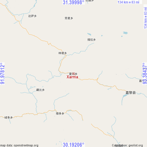
Xarma GPS coordinates[2]
30° 47' 52.512" North, 92° 40' 52.464" East
| Map corner | latitude | longitude |
|---|---|---|
| Upper-left | 31.39998°, | 91.97812° |
| Center: | 30.79792°, | 92.68124° |
| Lower-right: | 30.19206°, | 93.38437° |
| Map W x H: | 134.3×134.3 km | = 83.5×83.5mi |
| max Lat: | 53.31946° ⇑47.1% North |
| Xarma: | 30.79792° |
| min Lat: | ⇓52.9% South 18.22056° |
| min Long | Xarma | max Long |
| 75.07348° | 92.68124° | 134.28917° |
| W 3.3%⇐ | ⇒96.7% E |
Elevation
Elevation of Xarma is 4837 m = 15869 ft, and this is 4352.2 m = 14279 ft above average elevation for this country.
| Max E: |
5622 m = 18445 ft | 0.099999999999994% |
| Xarma | 4837 m 15869 ft | |
| Avg. | 484.8 m = 1591 ft | |
Min E: |
-3 m = -10 ft | 99.9% |
See also: China elevation on elevation.city.
Geographical zone
Xarma is located in North temperate zone (between Tropic of Cancer and the Arctic Circle). Distance of this Northern Tropic circle is 818.5 km =508.6 mi to South.| Distance of | km | miles | from Xarma |
|---|---|---|---|
| North Pole | 6582.7 | 4090.3 | to North |
| Arctic Circle | 3976.8 | 2471.1 | to North |
| Tropic Cancer | 818.5 | 508.6 | to South |
| Equator | 3424.4 | 2127.8 | to South |


Nearby cities:
15 places around Xarma: (largest is in red/bold)
• Arza
56.3 km =35 mi,  107°
107°
• Codoi
43.1 km =26.8 mi,  215°
215°
• Cola
35.7 km =22.2 mi,  28°
28°
• Dagsar
64.7 km =40.2 mi,  324°
324°
• Goqung
66.6 km =41.4 mi,  85°
85°
• Lhari
63 km =39.1 mi,  95°
95°
• Lingti
20.5 km =12.7 mi,  330°
330°
• Lomai
51 km =31.7 mi,  355°
355°
• Nagqu
93.3 km =58 mi, 316°
• Nagqu
96 km =59.7 mi, 321°
• Nyima
83 km =51.6 mi,  3°
3°
• Rongdoi
72.3 km =44.9 mi,  236°
236°
• Sexiong
68.6 km =42.6 mi,  12°
12°
• Yoiqag
81.3 km =50.5 mi,  255°
255°
• Zangbi
33.5 km =20.8 mi, 244°
Sources, notices
• [Note1] Compared only with cities in China existing in our database
• [Src1] Map data: © OpenStreetMap contributors (CC-BY-SA)
• [Src2] Other city data from geonames.org with taken over terms of usage.
• [Src3] Geographical zone / Annual Mean Temperature by Robert A. Rohde @ Wikipedia
