Gengqing geodata
Gengqing (Sichuan) is a seat of a third-order administrative division; located in China in Asia/Shanghai (GMT+8) time zone. In our database, there are 1268 cities with bigger population. Compared to other cities in China, 60.2% of cities are located further ↓South; 95.3% of cities are located further →East and 98.7% of cities have lower elevation than Gengqing. Note1


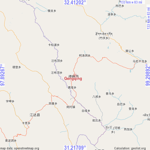
Gengqing GPS coordinates[2]
31° 48' 59.364" North, 98° 35' 44.844" East
| Map corner | latitude | longitude |
|---|---|---|
| Upper-left | 32.41202°, | 97.89267° |
| Center: | 31.81649°, | 98.59579° |
| Lower-right: | 31.21709°, | 99.29892° |
| Map W x H: | 132.9×132.9 km | = 82.6×82.6mi |
| max Lat: | 53.31946° ⇑39.8% North |
| Gengqing: | 31.81649° |
| min Lat: | ⇓60.2% South 18.22056° |
| min Long | Gengqing | max Long |
| 75.07348° | 98.59579° | 134.28917° |
| W 4.7%⇐ | ⇒95.3% E |
Elevation
Elevation of Gengqing is 4008 m = 13150 ft, and this is 3523.2 m = 11559 ft above average elevation for this country.
| Max E: |
5622 m = 18445 ft | 1.3% |
| Gengqing | 4008 m 13150 ft | |
| Avg. | 484.8 m = 1591 ft | |
Min E: |
-3 m = -10 ft | 98.7% |
See also: China elevation on elevation.city.
Geographical zone
Gengqing is located in North temperate zone (between Tropic of Cancer and the Arctic Circle). Distance of this Northern Tropic circle is 931.7 km =578.9 mi to South.| Distance of | km | miles | from Gengqing |
|---|---|---|---|
| North Pole | 6469.4 | 4019.9 | to North |
| Arctic Circle | 3863.5 | 2400.7 | to North |
| Tropic Cancer | 931.7 | 578.9 | to South |
| Equator | 3537.7 | 2198.2 | to South |


Nearby cities:
15 places around Gengqing: (largest is in red/bold)
• Baitang
175.8 km =109.2 mi,  309°
309°
• Ganzi
133.9 km =83.2 mi,  99°
99°
• Jomda
50.9 km =31.6 mi,  225°
225°
• Molo
110.7 km =68.8 mi,  196°
196°
• Moluo
122 km =75.8 mi, 202°
• Mozhong
174.8 km =108.6 mi,  286°
286°
• Nyagla
167.5 km =104.1 mi,  278°
278°
• Qamdo
154.4 km =95.9 mi,  240°
240°
• Qümong
137.3 km =85.3 mi,  340°
340°
• Seke
171.4 km =106.5 mi,  72°
72°
• Shang Boingor
152 km =94.4 mi,  37°
37°
• Xia Boingor
150.8 km =93.7 mi, 43°
• Xiao Surmang
141.4 km =87.9 mi, 294°
• Xiwu
187.2 km =116.3 mi,  321°
321°
• Yanduo
161.5 km =100.4 mi,  217°
217°
Sources, notices
• [Note1] Compared only with cities in China existing in our database
• [Src1] Map data: © OpenStreetMap contributors (CC-BY-SA)
• [Src2] Other city data from geonames.org with taken over terms of usage.
• [Src3] Geographical zone / Annual Mean Temperature by Robert A. Rohde @ Wikipedia
