Baitang geodata
Baitang (Qinghai) is a seat of a fourth-order administrative division; located in China in Asia/Shanghai (GMT+8) time zone. In our database, there are 1268 cities with bigger population. Compared to other cities in China, 65.3% of cities are located further ↓South; 95.6% of cities are located further →East and 98.5% of cities have lower elevation than Baitang. Note1


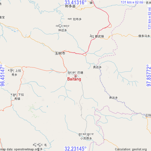
Baitang GPS coordinates[2]
32° 49' 27.372" North, 97° 9' 16.524" East
| Map corner | latitude | longitude |
|---|---|---|
| Upper-left | 33.41316°, | 96.45147° |
| Center: | 32.82427°, | 97.15459° |
| Lower-right: | 32.23145°, | 97.85772° |
| Map W x H: | 131.4×131.4 km | = 81.6×81.6mi |
| max Lat: | 53.31946° ⇑34.7% North |
| Baitang: | 32.82427° |
| min Lat: | ⇓65.3% South 18.22056° |
| min Long | Baitang | max Long |
| 75.07348° | 97.15459° | 134.28917° |
| W 4.4%⇐ | ⇒95.6% E |
Elevation
Elevation of Baitang is 3934 m = 12907 ft, and this is 3449.2 m = 11316 ft above average elevation for this country.
| Max E: |
5622 m = 18445 ft | 1.5% |
| Baitang | 3934 m 12907 ft | |
| Avg. | 484.8 m = 1591 ft | |
Min E: |
-3 m = -10 ft | 98.5% |
See also: China elevation on elevation.city.
Geographical zone
Baitang is located in North temperate zone (between Tropic of Cancer and the Arctic Circle). Distance of this Northern Tropic circle is 1043.8 km =648.6 mi to South.| Distance of | km | miles | from Baitang |
|---|---|---|---|
| North Pole | 6357.3 | 3950.2 | to North |
| Arctic Circle | 3751.5 | 2331.1 | to North |
| Tropic Cancer | 1043.8 | 648.6 | to South |
| Equator | 3649.7 | 2267.8 | to South |


Nearby cities:
15 places around Baitang: (largest is in red/bold)
• Anchong
86.3 km =53.6 mi,  325°
325°
• Gaduo
103.7 km =64.4 mi,  335°
335°
• Gyairong
84.4 km =52.4 mi,  305°
305°
• Gyobrag
97.8 km =60.8 mi,  253°
253°
• Lab
49.8 km =30.9 mi,  358°
358°
• Mozhong
69.2 km =43 mi,  206°
206°
• Nyagla
91.9 km =57.1 mi,  198°
198°
• Qiezha
102.7 km =63.8 mi,  215°
215°
• Qümong
89.7 km =55.7 mi,  79°
79°
• Shanglaxiu
53.4 km =33.2 mi,  273°
273°
• Xangda
93.6 km =58.2 mi, 222°
• Xialaxiu
53.8 km =33.4 mi, 251°
• Xiao Surmang
53.2 km =33.1 mi,  172°
172°
• Xiwu
38.5 km =23.9 mi,  27°
27°
• Zhoinda
43.4 km =27 mi, 344°
Sources, notices
• [Note1] Compared only with cities in China existing in our database
• [Src1] Map data: © OpenStreetMap contributors (CC-BY-SA)
• [Src2] Other city data from geonames.org with taken over terms of usage.
• [Src3] Geographical zone / Annual Mean Temperature by Robert A. Rohde @ Wikipedia
