Jomda geodata
Jomda (Tibet) is a seat of a third-order administrative division; located in China in Asia/Shanghai (GMT+8) time zone. In our database, there are 1268 cities with bigger population. Compared to other cities in China, 58.4% of cities are located further ↓South; 95.4% of cities are located further →East and 97.9% of cities have lower elevation than Jomda. Note1


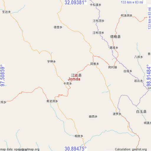
Jomda GPS coordinates[2]
31° 29' 46.32" North, 98° 12' 42.156" East
| Map corner | latitude | longitude |
|---|---|---|
| Upper-left | 32.09381°, | 97.50859° |
| Center: | 31.4962°, | 98.21171° |
| Lower-right: | 30.89475°, | 98.91484° |
| Map W x H: | 133.3×133.3 km | = 82.8×82.8mi |
| max Lat: | 53.31946° ⇑41.6% North |
| Jomda: | 31.4962° |
| min Lat: | ⇓58.4% South 18.22056° |
| min Long | Jomda | max Long |
| 75.07348° | 98.21171° | 134.28917° |
| W 4.6%⇐ | ⇒95.4% E |
Elevation
Elevation of Jomda is 3605 m = 11827 ft, and this is 3120.2 m = 10237 ft above average elevation for this country.
| Max E: |
5622 m = 18445 ft | 2.1% |
| Jomda | 3605 m 11827 ft | |
| Avg. | 484.8 m = 1591 ft | |
Min E: |
-3 m = -10 ft | 97.9% |
See also: China elevation on elevation.city.
Geographical zone
Jomda is located in North temperate zone (between Tropic of Cancer and the Arctic Circle). Distance of this Northern Tropic circle is 896.1 km =556.8 mi to South.| Distance of | km | miles | from Jomda |
|---|---|---|---|
| North Pole | 6505 | 4042 | to North |
| Arctic Circle | 3899.1 | 2422.8 | to North |
| Tropic Cancer | 896.1 | 556.8 | to South |
| Equator | 3502 | 2176 | to South |


Nearby cities:
15 places around Jomda: (largest is in red/bold)
• Baitang
178.1 km =110.7 mi,  326°
326°
• Ganzi
169.5 km =105.3 mi,  85°
85°
• Gengqing
50.9 km =31.6 mi,  45°
45°
• Molo
71 km =44.1 mi,  175°
175°
• Moluo
77.7 km =48.3 mi,  187°
187°
• Mozhong
157 km =97.6 mi,  303°
303°
• Nyagla
143.1 km =88.9 mi, 295°
• Qamdo
106.1 km =65.9 mi,  247°
247°
• Qiezha
172.8 km =107.4 mi,  291°
291°
• Qümong
165.1 km =102.6 mi,  356°
356°
• Racaka
161.1 km =100.1 mi,  266°
266°
• Samdo
156.3 km =97.1 mi,  258°
258°
• Xangda
181.7 km =112.9 mi, 295°
• Xiao Surmang
132.4 km =82.3 mi,  315°
315°
• Yanduo
111.4 km =69.2 mi,  213°
213°
Sources, notices
• [Note1] Compared only with cities in China existing in our database
• [Src1] Map data: © OpenStreetMap contributors (CC-BY-SA)
• [Src2] Other city data from geonames.org with taken over terms of usage.
• [Src3] Geographical zone / Annual Mean Temperature by Robert A. Rohde @ Wikipedia
