Qamdo geodata
Qamdo (Tibet) is a seat of a second-order administrative division; located in China in Asia/Shanghai (GMT+8) time zone. With population of 86,280 people, there are 493 cities with bigger population in this country. Compared to other cities in China, 55.8% of cities are located further ↓South; 95.6% of cities are located further →East and 97.2% of cities have lower elevation than Qamdo. Note1


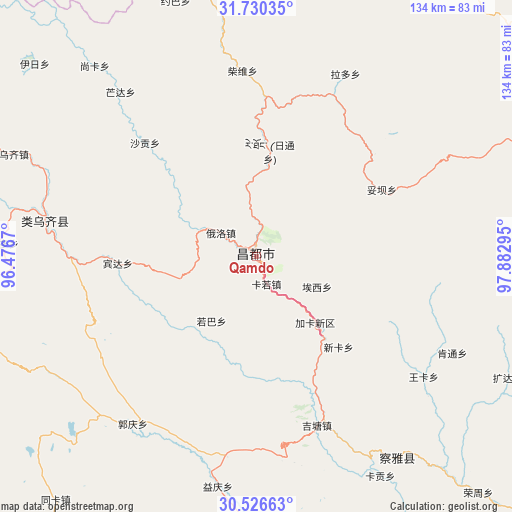
Qamdo GPS coordinates[2]
31° 7' 49.44" North, 97° 10' 47.352" East
| Map corner | latitude | longitude |
|---|---|---|
| Upper-left | 31.73035°, | 96.4767° |
| Center: | 31.1304°, | 97.17982° |
| Lower-right: | 30.52663°, | 97.88295° |
| Map W x H: | 133.8×133.8 km | = 83.1×83.1mi |
| max Lat: | 53.31946° ⇑44.2% North |
| Qamdo: | 31.1304° |
| min Lat: | ⇓55.8% South 18.22056° |
| min Long | Qamdo | max Long |
| 75.07348° | 97.17982° | 134.28917° |
| W 4.4%⇐ | ⇒95.6% E |
Elevation
Elevation of Qamdo is 3235 m = 10614 ft, and this is 2750.2 m = 9023 ft above average elevation for this country.
| Max E: |
5622 m = 18445 ft | 2.8% |
| Qamdo | 3235 m 10614 ft | |
| Avg. | 484.8 m = 1591 ft | |
Min E: |
-3 m = -10 ft | 97.2% |
See also: Qamdo elevation on elevation.city.
Geographical zone
Qamdo is located in North temperate zone (between Tropic of Cancer and the Arctic Circle). Distance of this Northern Tropic circle is 855.5 km =531.6 mi to South.| Distance of | km | miles | from Qamdo |
|---|---|---|---|
| North Pole | 6545.7 | 4067.3 | to North |
| Arctic Circle | 3939.8 | 2448.1 | to North |
| Tropic Cancer | 855.5 | 531.6 | to South |
| Equator | 3461.4 | 2150.8 | to South |


Nearby cities:
15 places around Qamdo: (largest is in red/bold)
• Baima
121.9 km =75.7 mi,  191°
191°
• Jiqu
135.8 km =84.4 mi,  312°
312°
• Jomda
106.1 km =65.9 mi,  67°
67°
• Molo
108.4 km =67.4 mi,  106°
106°
• Moluo
95 km =59 mi, 112°
• Mozhong
131.2 km =81.5 mi,  344°
344°
• Nyagla
106.3 km =66.1 mi, 342°
• Qiezha
122.5 km =76.1 mi,  329°
329°
• Racaka
69.8 km =43.4 mi,  295°
295°
• Samdo
56 km =34.8 mi,  279°
279°
• Xangda
136.7 km =84.9 mi, 330°
• Xiao Surmang
135.7 km =84.3 mi,  2°
2°
• Xiexiong
151.5 km =94.1 mi, 281°
• Yanduo
64.6 km =40.1 mi,  144°
144°
• Zito
135.3 km =84.1 mi,  251°
251°
Sources, notices
• [Note1] Compared only with cities in China existing in our database
• [Src1] Map data: © OpenStreetMap contributors (CC-BY-SA)
• [Src2] Other city data from geonames.org with taken over terms of usage.
• [Src3] Geographical zone / Annual Mean Temperature by Robert A. Rohde @ Wikipedia
