Nyagla geodata
Nyagla (Qinghai) is a seat of a fourth-order administrative division; located in China in Asia/Shanghai (GMT+8) time zone. In our database, there are 1268 cities with bigger population. Compared to other cities in China, 61.4% of cities are located further ↓South; 95.7% of cities are located further →East and 97.9% of cities have lower elevation than Nyagla. Note1


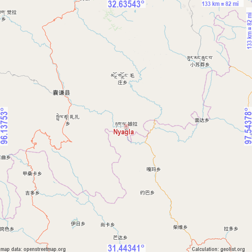
Nyagla GPS coordinates[2]
32° 2' 28.896" North, 96° 50' 26.34" East
| Map corner | latitude | longitude |
|---|---|---|
| Upper-left | 32.63543°, | 96.13753° |
| Center: | 32.04136°, | 96.84065° |
| Lower-right: | 31.44341°, | 97.54378° |
| Map W x H: | 132.5×132.5 km | = 82.3×82.3mi |
| max Lat: | 53.31946° ⇑38.6% North |
| Nyagla: | 32.04136° |
| min Lat: | ⇓61.4% South 18.22056° |
| min Long | Nyagla | max Long |
| 75.07348° | 96.84065° | 134.28917° |
| W 4.3%⇐ | ⇒95.7% E |
Elevation
Elevation of Nyagla is 3575 m = 11729 ft, and this is 3090.2 m = 10138 ft above average elevation for this country.
| Max E: |
5622 m = 18445 ft | 2.1% |
| Nyagla | 3575 m 11729 ft | |
| Avg. | 484.8 m = 1591 ft | |
Min E: |
-3 m = -10 ft | 97.9% |
See also: China elevation on elevation.city.
Geographical zone
Nyagla is located in North temperate zone (between Tropic of Cancer and the Arctic Circle). Distance of this Northern Tropic circle is 956.7 km =594.5 mi to South.| Distance of | km | miles | from Nyagla |
|---|---|---|---|
| North Pole | 6444.4 | 4004.4 | to North |
| Arctic Circle | 3838.5 | 2385.1 | to North |
| Tropic Cancer | 956.7 | 594.5 | to South |
| Equator | 3562.7 | 2213.8 | to South |


Nearby cities:
15 places around Nyagla: (largest is in red/bold)
• Baitang
91.9 km =57.1 mi,  18°
18°
• Gaxung
111.6 km =69.3 mi,  271°
271°
• Gyobrag
87 km =54.1 mi,  312°
312°
• Jinisai
79 km =49.1 mi, 272°
• Jiqu
69 km =42.9 mi,  261°
261°
• Mozhong
25.5 km =15.8 mi,  355°
355°
• Qamdo
106.3 km =66.1 mi,  162°
162°
• Qiezha
31 km =19.3 mi,  276°
276°
• Racaka
77.6 km =48.2 mi,  203°
203°
• Samdo
94.8 km =58.9 mi,  193°
193°
• Shanglaxiu
93.5 km =58.1 mi,  345°
345°
• Xangda
38.7 km =24 mi,  298°
298°
• Xialaxiu
72.9 km =45.3 mi,  342°
342°
• Xiao Surmang
50.4 km =31.3 mi,  47°
47°
• Zhexiao
116.9 km =72.6 mi, 297°
Sources, notices
• [Note1] Compared only with cities in China existing in our database
• [Src1] Map data: © OpenStreetMap contributors (CC-BY-SA)
• [Src2] Other city data from geonames.org with taken over terms of usage.
• [Src3] Geographical zone / Annual Mean Temperature by Robert A. Rohde @ Wikipedia
