Dibulla geodata
Dibulla (La Guajira) is a seat of a second-order administrative division; located in Colombia in America/Bogota (GMT-5) time zone. With population of 4,402 people, there are 547 cities with bigger population in this country. Compared to other cities in Colombia, 99.4% of cities are located further ↓South; 80.2% of cities are located further ←West and 99.2% of cities have higher elevation than Dibulla. Note1


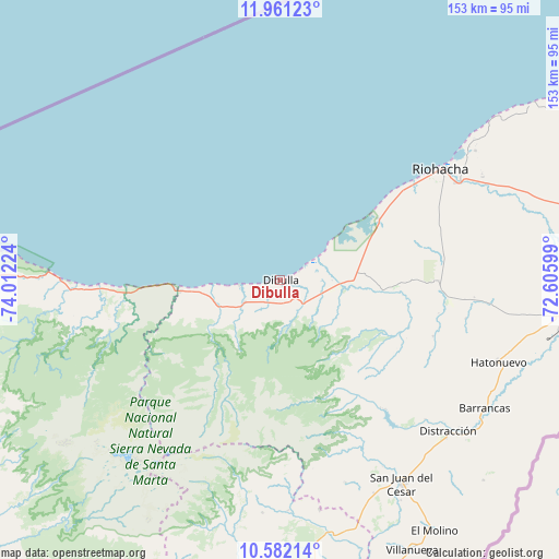
Dibulla GPS coordinates[2]
11° 16' 21.036" North, 73° 18' 32.796" West
| Map corner | latitude | longitude |
|---|---|---|
| Upper-left | 11.96123°, | -74.01224° |
| Center: | 11.27251°, | -73.30911° |
| Lower-right: | 10.58214°, | -72.60599° |
| Map W x H: | 153.3×153.3 km | = 95.3×95.3mi |
| max Lat: | 13.38166° ⇑0.6% North |
| Dibulla: | 11.27251° |
| min Lat: | ⇓99.4% South -4.21528° |
| min Long | Dibulla | max Long |
| -81.70636° | -73.30911° | -67.06996° |
| W 80.2%⇐ | ⇒19.8% E |
Elevation
Elevation of Dibulla is 4 m = 13 ft, and this is 1145.3 m = 3758 ft below average elevation for this country.
| Max E: |
3342 m = 10965 ft | 99.2% |
| Avg. | 1149.3 m = 3771 ft | |
| Dibulla | 4 m = 13 ft | |
Min E: |
1 m = 3 ft | 0.8% |
See also: Colombia elevation on elevation.city.
Geographical zone
Dibulla is located in North Torrid zone (between Equator and Tropic of Cancer). Distance of Equator is 1253.4 km =778.8 mi to South.| Distance of | km | miles | from Dibulla |
|---|---|---|---|
| North Pole | 8753.7 | 5439.3 | to North |
| Arctic Circle | 6147.8 | 3820.1 | to North |
| Tropic Cancer | 1352.5 | 840.4 | to North |
| Equator | 1253.4 | 778.8 | to South |


Nearby cities:
15 places around Dibulla: (largest is in red/bold)
• Albania
79.1 km =49.2 mi,  99°
99°
• Barrancas
66.2 km =41.1 mi,  122°
122°
• Distracción
62.1 km =38.6 mi,  132°
132°
• El Molino
80.7 km =50.1 mi,  148°
148°
• Fonseca
66.1 km =41.1 mi, 130°
• La Jagua del Pilar
88.6 km =55.1 mi,  162°
162°
• La Paz
99.9 km =62.1 mi,  171°
171°
• Manaure Balcón del Cesar
102.4 km =63.6 mi, 162°
• Pueblo Bello
99.6 km =61.9 mi,  197°
197°
• Riohacha
53.2 km =33.1 mi,  55°
55°
• San Juan del Cesar
65 km =40.4 mi, 149°
• Santa Marta
97.1 km =60.3 mi,  267°
267°
• Urumita
85.7 km =53.3 mi, 157°
• Valledupar
90.2 km =56 mi,  176°
176°
• Villanueva
82.2 km =51.1 mi, 154°
Sources, notices
• [Note1] Compared only with cities in Colombia existing in our database
• [Src1] Map data: © OpenStreetMap contributors (CC-BY-SA)
• [Src2] Other city data from geonames.org with taken over terms of usage.
• [Src3] Geographical zone / Annual Mean Temperature by Robert A. Rohde @ Wikipedia
