Albania geodata
Albania (La Guajira) is a seat of a second-order administrative division; located in Colombia in America/Bogota (GMT-5) time zone. With population of 6,364 people, there are 432 cities with bigger population in this country. Compared to other cities in Colombia, 99.2% of cities are located further ↓South; 94.5% of cities are located further ←West and 81.7% of cities have higher elevation than Albania. Note1


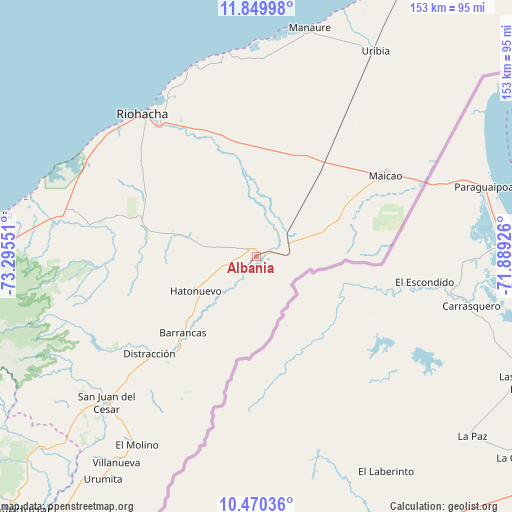
Albania GPS coordinates[2]
11° 9' 39.564" North, 72° 35' 32.568" West
| Map corner | latitude | longitude |
|---|---|---|
| Upper-left | 11.84998°, | -73.29551° |
| Center: | 11.16099°, | -72.59238° |
| Lower-right: | 10.47036°, | -71.88926° |
| Map W x H: | 153.4×153.4 km | = 95.3×95.3mi |
| max Lat: | 13.38166° ⇑0.8% North |
| Albania: | 11.16099° |
| min Lat: | ⇓99.2% South -4.21528° |
| min Long | Albania | max Long |
| -81.70636° | -72.59238° | -67.06996° |
| W 94.5%⇐ | ⇒5.5% E |
Elevation
Elevation of Albania is 94 m = 308 ft, and this is 1055.3 m = 3462 ft below average elevation for this country.
| Max E: |
3342 m = 10965 ft | 81.7% |
| Avg. | 1149.3 m = 3771 ft | |
| Albania | 94 m = 308 ft | |
Min E: |
1 m = 3 ft | 18.3% |
See also: Colombia elevation on elevation.city.
Geographical zone
Albania is located in North Torrid zone (between Equator and Tropic of Cancer). Distance of Equator is 1241 km =771.1 mi to South.| Distance of | km | miles | from Albania |
|---|---|---|---|
| North Pole | 8766.1 | 5447 | to North |
| Arctic Circle | 6160.2 | 3827.8 | to North |
| Tropic Cancer | 1364.9 | 848.1 | to North |
| Equator | 1241 | 771.1 | to South |


Nearby cities:
15 places around Albania: (largest is in red/bold)
• Barrancas
31.7 km =19.7 mi,  224°
224°
• Dibulla
79.1 km =49.2 mi,  279°
279°
• Distracción
43.4 km =27 mi,  227°
227°
• El Molino
67.1 km =41.7 mi,  212°
212°
• Fonseca
41.4 km =25.7 mi, 222°
• La Jagua del Pilar
89.3 km =55.5 mi, 215°
• Maicao
45.4 km =28.2 mi,  57°
57°
• Manaure
70.2 km =43.6 mi,  13°
13°
• Manaure Balcón del Cesar
98 km =60.9 mi, 209°
• Riohacha
54.7 km =34 mi,  321°
321°
• San Juan del Cesar
62.4 km =38.8 mi, 225°
• Uribia
71.1 km =44.2 mi,  30°
30°
• Urumita
81.1 km =50.4 mi, 214°
• Valledupar
106 km =65.9 mi, 222°
• Villanueva
74.6 km =46.4 mi, 214°
Sources, notices
• [Note1] Compared only with cities in Colombia existing in our database
• [Src1] Map data: © OpenStreetMap contributors (CC-BY-SA)
• [Src2] Other city data from geonames.org with taken over terms of usage.
• [Src3] Geographical zone / Annual Mean Temperature by Robert A. Rohde @ Wikipedia
