Gachantivá geodata
Gachantivá (Boyacá) is a seat of a second-order administrative division; located in Colombia in America/Bogota (GMT-5) time zone. With population of 534 people, there are 1025 cities with bigger population in this country. Compared to other cities in Colombia, 55.2% of cities are located further ↓South; 74.6% of cities are located further ←West and 87.6% of cities have lower elevation than Gachantivá. Note1


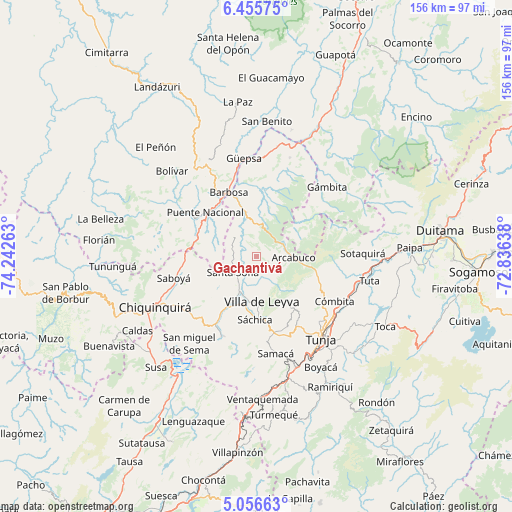
Gachantivá GPS coordinates[2]
5° 45' 23.832" North, 73° 32' 22.2" West
| Map corner | latitude | longitude |
|---|---|---|
| Upper-left | 6.45575°, | -74.24263° |
| Center: | 5.75662°, | -73.5395° |
| Lower-right: | 5.05663°, | -72.83638° |
| Map W x H: | 155.6×155.6 km | = 96.7×96.7mi |
| max Lat: | 13.38166° ⇑44.8% North |
| Gachantivá: | 5.75662° |
| min Lat: | ⇓55.2% South -4.21528° |
| min Long | Gachantivá | max Long |
| -81.70636° | -73.5395° | -67.06996° |
| W 74.6%⇐ | ⇒25.4% E |
Elevation
Elevation of Gachantivá is 2431 m = 7976 ft, and this is 1281.7 m = 4205 ft above average elevation for this country.
| Max E: |
3342 m = 10965 ft | 12.4% |
| Gachantivá | 2431 m 7976 ft | |
| Avg. | 1149.3 m = 3771 ft | |
Min E: |
1 m = 3 ft | 87.6% |
See also: Colombia elevation on elevation.city.
Geographical zone
Gachantivá is located in North Torrid zone (between Equator and Tropic of Cancer). Distance of Equator is 640.1 km =397.7 mi to South.| Distance of | km | miles | from Gachantivá |
|---|---|---|---|
| North Pole | 9367 | 5820.4 | to North |
| Arctic Circle | 6761.1 | 4201.2 | to North |
| Tropic Cancer | 1965.8 | 1221.5 | to North |
| Equator | 640.1 | 397.7 | to South |


Nearby cities:
15 places around Gachantivá: (largest is in red/bold)
• Arcabuco
11.4 km =7.1 mi,  91°
91°
• Barbosa
21.2 km =13.2 mi,  336°
336°
• Chíquiza
18 km =11.2 mi,  160°
160°
• Cucaita
25.5 km =15.8 mi, 158°
• La Capilla
9.1 km =5.7 mi,  128°
128°
• Moniquirá
13.8 km =8.6 mi, 344°
• Puente Nacional
20.4 km =12.7 mi,  311°
311°
• Saboyá
26.3 km =16.3 mi,  255°
255°
• Santa Sofía
8.9 km =5.5 mi,  233°
233°
• Sora
23.5 km =14.6 mi, 155°
• Sutamarchán
17.9 km =11.1 mi,  208°
208°
• Sáchica
19.1 km =11.9 mi,  180°
180°
• Tinjacá
22.9 km =14.2 mi, 210°
• Togüí
20 km =12.4 mi,  8°
8°
• Villa de Leyva
13.7 km =8.5 mi,  172°
172°
Sources, notices
• [Note1] Compared only with cities in Colombia existing in our database
• [Src1] Map data: © OpenStreetMap contributors (CC-BY-SA)
• [Src2] Other city data from geonames.org with taken over terms of usage.
• [Src3] Geographical zone / Annual Mean Temperature by Robert A. Rohde @ Wikipedia
