Vigía del Fuerte geodata
Vigía del Fuerte (Antioquia) is a seat of a second-order administrative division; located in Colombia in America/Bogota (GMT-5) time zone. With population of 4,638 people, there are 538 cities with bigger population in this country. Compared to other cities in Colombia, 69.7% of cities are located further ↓South; 91.4% of cities are located further →East and 100% of cities have higher elevation than Vigía del Fuerte. Note1


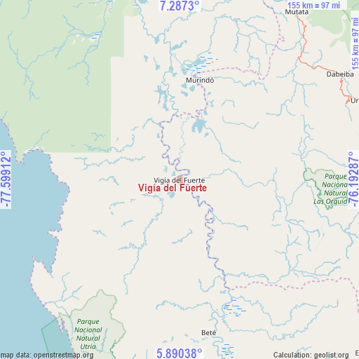
Vigía del Fuerte GPS coordinates[2]
6° 35' 21.588" North, 76° 53' 45.564" West
| Map corner | latitude | longitude |
|---|---|---|
| Upper-left | 7.2873°, | -77.59912° |
| Center: | 6.58933°, | -76.89599° |
| Lower-right: | 5.89038°, | -76.19287° |
| Map W x H: | 155.3×155.3 km | = 96.5×96.5mi |
| max Lat: | 13.38166° ⇑30.3% North |
| Vigía del Fuerte: | 6.58933° |
| min Lat: | ⇓69.7% South -4.21528° |
| min Long | Vigía del Fuer | max Long |
| -81.70636° | -76.89599° | -67.06996° |
| W 8.6%⇐ | ⇒91.4% E |
Elevation
Elevation of Vigía del Fuerte is 1 m = 3 ft, and this is 1148.3 m = 3767 ft below average elevation for this country.
| Max E: |
3342 m = 10965 ft | 100% |
| Avg. | 1149.3 m = 3771 ft | |
| Vigía del Fuerte | 1 m = 3 ft | |
Min E: |
1 m = 3 ft | 0% |
See also: Colombia elevation on elevation.city.
Geographical zone
Vigía del Fuerte is located in North Torrid zone (between Equator and Tropic of Cancer). Distance of Equator is 732.7 km =455.3 mi to South.| Distance of | km | miles | from Vigía del Fuerte |
|---|---|---|---|
| North Pole | 9274.4 | 5762.8 | to North |
| Arctic Circle | 6668.5 | 4143.6 | to North |
| Tropic Cancer | 1873.3 | 1164 | to North |
| Equator | 732.7 | 455.3 | to South |


Nearby cities:
15 places around Vigía del Fuerte: (largest is in red/bold)
• Abriaquí
92 km =57.2 mi,  87°
87°
• Bahía Solano
69.2 km =43 mi,  234°
234°
• Bellavista
3.9 km =2.4 mi,  159°
159°
• Beté
67.3 km =41.8 mi,  169°
169°
• Caicedo
103 km =64 mi,  101°
101°
• Cañasgordas
97.8 km =60.8 mi,  79°
79°
• Curbaradó
63.7 km =39.6 mi,  352°
352°
• Dabeiba
82.9 km =51.5 mi,  56°
56°
• Frontino
86.6 km =53.8 mi, 76°
• Murindó
44.3 km =27.5 mi,  10°
10°
• Mutatá
88.8 km =55.2 mi,  34°
34°
• Quibdó
103.2 km =64.1 mi, 165°
• Riosucio
98.1 km =61 mi, 345°
• Uramita
86.8 km =53.9 mi,  66°
66°
• Urrao
89.4 km =55.6 mi,  109°
109°
Sources, notices
• [Note1] Compared only with cities in Colombia existing in our database
• [Src1] Map data: © OpenStreetMap contributors (CC-BY-SA)
• [Src2] Other city data from geonames.org with taken over terms of usage.
• [Src3] Geographical zone / Annual Mean Temperature by Robert A. Rohde @ Wikipedia
