Bellavista geodata
Bellavista (Chocó) is a seat of a second-order administrative division; located in Colombia in America/Bogota (GMT-5) time zone. With population of 1,396 people, there are 884 cities with bigger population in this country. Compared to other cities in Colombia, 69.3% of cities are located further ↓South; 91.3% of cities are located further →East and 100% of cities have higher elevation than Bellavista. Note1


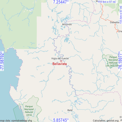
Bellavista GPS coordinates[2]
6° 33' 23.22" North, 76° 53' 2.004" West
| Map corner | latitude | longitude |
|---|---|---|
| Upper-left | 7.25447°, | -77.58702° |
| Center: | 6.55645°, | -76.88389° |
| Lower-right: | 5.85745°, | -76.18077° |
| Map W x H: | 155.3×155.3 km | = 96.5×96.5mi |
| max Lat: | 13.38166° ⇑30.7% North |
| Bellavista: | 6.55645° |
| min Lat: | ⇓69.3% South -4.21528° |
| min Long | Bellavista | max Long |
| -81.70636° | -76.88389° | -67.06996° |
| W 8.7%⇐ | ⇒91.3% E |
Elevation
Elevation of Bellavista is 1 m = 3 ft, and this is 1148.3 m = 3767 ft below average elevation for this country.
| Max E: |
3342 m = 10965 ft | 100% |
| Avg. | 1149.3 m = 3771 ft | |
| Bellavista | 1 m = 3 ft | |
Min E: |
1 m = 3 ft | 0% |
See also: Colombia elevation on elevation.city.
Geographical zone
Bellavista is located in North Torrid zone (between Equator and Tropic of Cancer). Distance of Equator is 729 km =453 mi to South.| Distance of | km | miles | from Bellavista |
|---|---|---|---|
| North Pole | 9278.1 | 5765.1 | to North |
| Arctic Circle | 6672.2 | 4145.9 | to North |
| Tropic Cancer | 1876.9 | 1166.3 | to North |
| Equator | 729 | 453 | to South |


Nearby cities:
15 places around Bellavista: (largest is in red/bold)
• Abriaquí
90.9 km =56.5 mi,  84°
84°
• Bahía Solano
68.2 km =42.4 mi,  237°
237°
• Beté
63.5 km =39.5 mi,  169°
169°
• Caicedo
101 km =62.8 mi,  99°
99°
• Cañasgordas
97.2 km =60.4 mi, 77°
• Curbaradó
67.6 km =42 mi,  351°
351°
• Dabeiba
83.9 km =52.1 mi,  53°
53°
• Frontino
86.3 km =53.6 mi,  73°
73°
• Murindó
47.7 km =29.6 mi,  8°
8°
• Mutatá
91.1 km =56.6 mi,  32°
32°
• Quibdó
99.3 km =61.7 mi, 165°
• Riosucio
102 km =63.4 mi, 345°
• Uramita
87.2 km =54.2 mi,  64°
64°
• Urrao
87 km =54.1 mi,  107°
107°
• Vigía del Fuerte
3.9 km =2.4 mi,  339°
339°
Sources, notices
• [Note1] Compared only with cities in Colombia existing in our database
• [Src1] Map data: © OpenStreetMap contributors (CC-BY-SA)
• [Src2] Other city data from geonames.org with taken over terms of usage.
• [Src3] Geographical zone / Annual Mean Temperature by Robert A. Rohde @ Wikipedia
