Uribia geodata
Uribia (La Guajira) is a seat of a second-order administrative division; located in Colombia in America/Bogota (GMT-5) time zone. With population of 7,519 people, there are 388 cities with bigger population in this country. Compared to other cities in Colombia, 99.7% of cities are located further ↓South; 97.2% of cities are located further ←West and 89.8% of cities have higher elevation than Uribia. Note1


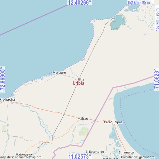
Uribia GPS coordinates[2]
11° 42' 54.18" North, 72° 15' 57.312" West
| Map corner | latitude | longitude |
|---|---|---|
| Upper-left | 12.40266°, | -72.96905° |
| Center: | 11.71505°, | -72.26592° |
| Lower-right: | 11.02573°, | -71.5628° |
| Map W x H: | 153.1×153.1 km | = 95.1×95.1mi |
| max Lat: | 13.38166° ⇑0.3% North |
| Uribia: | 11.71505° |
| min Lat: | ⇓99.7% South -4.21528° |
| min Long | Uribia | max Long |
| -81.70636° | -72.26592° | -67.06996° |
| W 97.2%⇐ | ⇒2.8% E |
Elevation
Elevation of Uribia is 30 m = 98 ft, and this is 1119.3 m = 3672 ft below average elevation for this country.
| Max E: |
3342 m = 10965 ft | 89.8% |
| Avg. | 1149.3 m = 3771 ft | |
| Uribia | 30 m = 98 ft | |
Min E: |
1 m = 3 ft | 10.2% |
See also: Colombia elevation on elevation.city.
Geographical zone
Uribia is located in North Torrid zone (between Equator and Tropic of Cancer). Distance of Equator is 1302.6 km =809.4 mi to South.| Distance of | km | miles | from Uribia |
|---|---|---|---|
| North Pole | 8704.5 | 5408.7 | to North |
| Arctic Circle | 6098.6 | 3789.5 | to North |
| Tropic Cancer | 1303.3 | 809.8 | to North |
| Equator | 1302.6 | 809.4 | to South |


Nearby cities:
15 places around Uribia: (largest is in red/bold)
• Albania
71.1 km =44.2 mi,  210°
210°
• Barrancas
102.1 km =63.4 mi, 214°
• Dibulla
123.9 km =77 mi,  246°
246°
• Distracción
113.3 km =70.4 mi,  216°
216°
• El Molino
138.2 km =85.9 mi, 211°
• Fonseca
112 km =69.6 mi, 214°
• La Jagua del Pilar
160.2 km =99.5 mi, 213°
• Maicao
37.5 km =23.3 mi,  175°
175°
• Manaure
20.6 km =12.8 mi,  288°
288°
• Manaure Balcón del Cesar
169.2 km =105.1 mi, 209°
• Riohacha
72.4 km =45 mi, 254°
• San Juan del Cesar
132.2 km =82.1 mi, 217°
• Urumita
152.2 km =94.6 mi, 212°
• Valledupar
176 km =109.4 mi, 217°
• Villanueva
145.6 km =90.5 mi, 212°
Sources, notices
• [Note1] Compared only with cities in Colombia existing in our database
• [Src1] Map data: © OpenStreetMap contributors (CC-BY-SA)
• [Src2] Other city data from geonames.org with taken over terms of usage.
• [Src3] Geographical zone / Annual Mean Temperature by Robert A. Rohde @ Wikipedia
