Riohacha geodata
Riohacha (La Guajira) is a seat of a first-order administrative division; located in Colombia in America/Bogota (GMT-5) time zone. With population of 92,431 people, there are 41 cities with bigger population in this country. Compared to other cities in Colombia, 99.6% of cities are located further ↓South; 88.5% of cities are located further ←West and 97.9% of cities have higher elevation than Riohacha. Note1


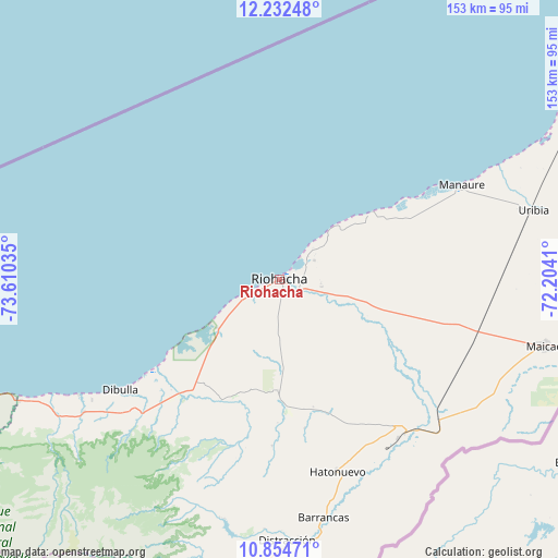
Riohacha GPS coordinates[2]
11° 32' 39.984" North, 72° 54' 25.992" West
| Map corner | latitude | longitude |
|---|---|---|
| Upper-left | 12.23248°, | -73.61035° |
| Center: | 11.54444°, | -72.90722° |
| Lower-right: | 10.85471°, | -72.2041° |
| Map W x H: | 153.2×153.2 km | = 95.2×95.2mi |
| max Lat: | 13.38166° ⇑0.4% North |
| Riohacha: | 11.54444° |
| min Lat: | ⇓99.6% South -4.21528° |
| min Long | Riohacha | max Long |
| -81.70636° | -72.90722° | -67.06996° |
| W 88.5%⇐ | ⇒11.5% E |
Elevation
Elevation of Riohacha is 7 m = 23 ft, and this is 1142.3 m = 3748 ft below average elevation for this country.
| Max E: |
3342 m = 10965 ft | 97.9% |
| Avg. | 1149.3 m = 3771 ft | |
| Riohacha | 7 m = 23 ft | |
Min E: |
1 m = 3 ft | 2.1% |
See also: Riohacha elevation on elevation.city.
Geographical zone
Riohacha is located in North Torrid zone (between Equator and Tropic of Cancer). Distance of Equator is 1283.6 km =797.6 mi to South.| Distance of | km | miles | from Riohacha |
|---|---|---|---|
| North Pole | 8723.4 | 5420.5 | to North |
| Arctic Circle | 6117.6 | 3801.3 | to North |
| Tropic Cancer | 1322.3 | 821.6 | to North |
| Equator | 1283.6 | 797.6 | to South |


Nearby cities:
15 places around Riohacha: (largest is in red/bold)
• Albania
54.7 km =34 mi,  141°
141°
• Barrancas
66.5 km =41.3 mi,  169°
169°
• Dibulla
53.2 km =33.1 mi,  235°
235°
• Distracción
71.9 km =44.7 mi,  178°
178°
• El Molino
99.1 km =61.6 mi, 181°
• Fonseca
73.5 km =45.7 mi, 175°
• La Jagua del Pilar
116.3 km =72.3 mi,  188°
188°
• Maicao
75.1 km =46.7 mi,  104°
104°
• Manaure
56.5 km =35.1 mi,  63°
63°
• Manaure Balcón del Cesar
128.8 km =80 mi, 186°
• San Juan del Cesar
86.6 km =53.8 mi, 186°
• Uribia
72.4 km =45 mi,  74°
74°
• Urumita
110.2 km =68.5 mi, 185°
• Valledupar
126 km =78.3 mi,  197°
197°
• Villanueva
104.5 km =64.9 mi, 184°
Sources, notices
• [Note1] Compared only with cities in Colombia existing in our database
• [Src1] Map data: © OpenStreetMap contributors (CC-BY-SA)
• [Src2] Other city data from geonames.org with taken over terms of usage.
• [Src3] Geographical zone / Annual Mean Temperature by Robert A. Rohde @ Wikipedia
