Colombia geodata
Colombia (Huila) is a seat of a second-order administrative division; located in Colombia in America/Bogota (GMT-5) time zone. With population of 2,388 people, there are 753 cities with bigger population in this country. Compared to other cities in Colombia, 82.2% of cities are located further ↑North; 50.6% of cities are located further ←West and 59.5% of cities have higher elevation than Colombia. Note1


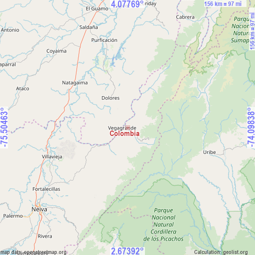
Colombia GPS coordinates[2]
3° 22' 33.816" North, 74° 48' 5.4" West
| Map corner | latitude | longitude |
|---|---|---|
| Upper-left | 4.07769°, | -75.50463° |
| Center: | 3.37606°, | -74.8015° |
| Lower-right: | 2.67392°, | -74.09838° |
| Map W x H: | 156.1×156.1 km | = 97×97mi |
| max Lat: | 13.38166° ⇑82.2% North |
| Colombia: | 3.37606° |
| min Lat: | ⇓17.8% South -4.21528° |
| min Long | Colombia | max Long |
| -81.70636° | -74.8015° | -67.06996° |
| W 50.6%⇐ | ⇒49.4% E |
Elevation
Elevation of Colombia is 781 m = 2562 ft, and this is 368.3 m = 1208 ft below average elevation for this country.
| Max E: |
3342 m = 10965 ft | 59.5% |
| Avg. | 1149.3 m = 3771 ft | |
| Colombia | 781 m = 2562 ft | |
Min E: |
1 m = 3 ft | 40.5% |
See also: Colombia elevation on elevation.city.
Geographical zone
Colombia is located in North Torrid zone (between Equator and Tropic of Cancer). Distance of Equator is 375.4 km =233.3 mi to South.| Distance of | km | miles | from Colombia |
|---|---|---|---|
| North Pole | 9631.7 | 5984.9 | to North |
| Arctic Circle | 7025.8 | 4365.6 | to North |
| Tropic Cancer | 2230.5 | 1386 | to North |
| Equator | 375.4 | 233.3 | to South |


Nearby cities:
15 places around Colombia: (largest is in red/bold)
• Aipe
51.2 km =31.8 mi,  250°
250°
• Alpujarra
14.7 km =9.1 mi,  276°
276°
• Baraya
37.3 km =23.2 mi,  228°
228°
• Coyaima
64.2 km =39.9 mi,  317°
317°
• Dolores
21 km =13 mi,  329°
329°
• Natagaima
42.4 km =26.3 mi,  309°
309°
• Prado
44.1 km =27.4 mi,  341°
341°
• Purificación
55.6 km =34.5 mi, 344°
• Saldaña
65.9 km =40.9 mi, 338°
• Santa Isabel
20.1 km =12.5 mi,  261°
261°
• Tello
50.7 km =31.5 mi, 227°
• Tres Esquinas
55.3 km =34.4 mi,  10°
10°
• Uribe
51.8 km =32.2 mi,  106°
106°
• Villarrica
66 km =41 mi,  19°
19°
• Villavieja
49.4 km =30.7 mi, 249°
Sources, notices
• [Note1] Compared only with cities in Colombia existing in our database
• [Src1] Map data: © OpenStreetMap contributors (CC-BY-SA)
• [Src2] Other city data from geonames.org with taken over terms of usage.
• [Src3] Geographical zone / Annual Mean Temperature by Robert A. Rohde @ Wikipedia
