Dolores geodata
Dolores (Tolima) is a seat of a second-order administrative division; located in Colombia in America/Bogota (GMT-5) time zone. In our database, there are 1053 cities with bigger population. Compared to other cities in Colombia, 81.4% of cities are located further ↑North; 51.7% of cities are located further →East and 59% of cities have lower elevation than Dolores. Note1


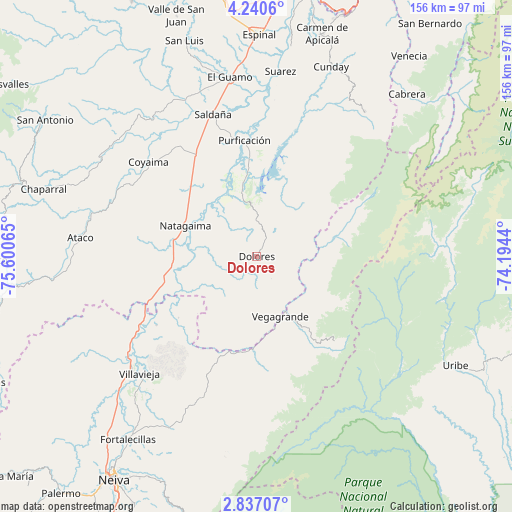
Dolores GPS coordinates[2]
3° 32' 20.76" North, 74° 53' 51.072" West
| Map corner | latitude | longitude |
|---|---|---|
| Upper-left | 4.2406°, | -75.60065° |
| Center: | 3.5391°, | -74.89752° |
| Lower-right: | 2.83707°, | -74.1944° |
| Map W x H: | 156.1×156.1 km | = 97×97mi |
| max Lat: | 13.38166° ⇑81.4% North |
| Dolores: | 3.5391° |
| min Lat: | ⇓18.6% South -4.21528° |
| min Long | Dolores | max Long |
| -81.70636° | -74.89752° | -67.06996° |
| W 48.3%⇐ | ⇒51.7% E |
Elevation
Elevation of Dolores is 1436 m = 4711 ft, and this is 286.7 m = 941 ft above average elevation for this country.
| Max E: |
3342 m = 10965 ft | 41% |
| Dolores | 1436 m 4711 ft | |
| Avg. | 1149.3 m = 3771 ft | |
Min E: |
1 m = 3 ft | 59% |
See also: Colombia elevation on elevation.city.
Geographical zone
Dolores is located in North Torrid zone (between Equator and Tropic of Cancer). Distance of Equator is 393.5 km =244.5 mi to South.| Distance of | km | miles | from Dolores |
|---|---|---|---|
| North Pole | 9613.6 | 5973.6 | to North |
| Arctic Circle | 7007.7 | 4354.4 | to North |
| Tropic Cancer | 2212.4 | 1374.7 | to North |
| Equator | 393.5 | 244.5 | to South |


Nearby cities:
15 places around Dolores: (largest is in red/bold)
• Aipe
51.6 km =32.1 mi,  226°
226°
• Alpujarra
16.9 km =10.5 mi,  193°
193°
• Ataco
54.1 km =33.6 mi,  276°
276°
• Baraya
46.2 km =28.7 mi,  201°
201°
• Colombia
21 km =13 mi,  149°
149°
• Coyaima
43.9 km =27.3 mi,  311°
311°
• La Chamba
54.3 km =33.7 mi,  3°
3°
• Natagaima
23.6 km =14.7 mi,  292°
292°
• Prado
23.9 km =14.9 mi,  351°
351°
• Purificación
35.7 km =22.2 mi, 353°
• Saldaña
45.3 km =28.1 mi,  343°
343°
• Santa Isabel
23 km =14.3 mi, 203°
• Tres Esquinas
41.8 km =26 mi,  29°
29°
• Villarrica
55 km =34.2 mi,  36°
36°
• Villavieja
50.3 km =31.3 mi, 225°
Sources, notices
• [Note1] Compared only with cities in Colombia existing in our database
• [Src1] Map data: © OpenStreetMap contributors (CC-BY-SA)
• [Src2] Other city data from geonames.org with taken over terms of usage.
• [Src3] Geographical zone / Annual Mean Temperature by Robert A. Rohde @ Wikipedia
