Santa Isabel geodata
Santa Isabel (Tolima) is a populated place; located in Colombia in America/Bogota (GMT-5) time zone. With population of 6,382 people, there are 429 cities with bigger population in this country. Compared to other cities in Colombia, 82.4% of cities are located further ↑North; 53.8% of cities are located further →East and 51% of cities have higher elevation than Santa Isabel. Note1


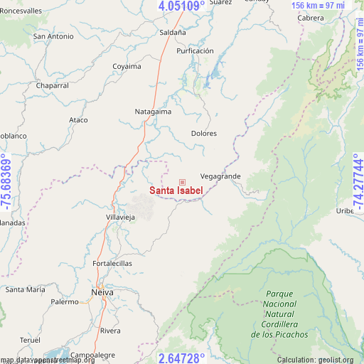
Santa Isabel GPS coordinates[2]
3° 20' 57.984" North, 74° 58' 50.016" West
| Map corner | latitude | longitude |
|---|---|---|
| Upper-left | 4.05109°, | -75.68369° |
| Center: | 3.34944°, | -74.98056° |
| Lower-right: | 2.64728°, | -74.27744° |
| Map W x H: | 156.1×156.1 km | = 97×97mi |
| max Lat: | 13.38166° ⇑82.4% North |
| Santa Isabel: | 3.34944° |
| min Lat: | ⇓17.6% South -4.21528° |
| min Long | Santa Isabel | max Long |
| -81.70636° | -74.98056° | -67.06996° |
| W 46.2%⇐ | ⇒53.8% E |
Elevation
Elevation of Santa Isabel is 1094 m = 3589 ft, and this is 55.3 m = 181 ft below average elevation for this country.
| Max E: |
3342 m = 10965 ft | 51% |
| Avg. | 1149.3 m = 3771 ft | |
| Santa Isabel | 1094 m = 3589 ft | |
Min E: |
1 m = 3 ft | 49% |
See also: Colombia elevation on elevation.city.
Geographical zone
Santa Isabel is located in North Torrid zone (between Equator and Tropic of Cancer). Distance of Equator is 372.4 km =231.4 mi to South.| Distance of | km | miles | from Santa Isabel |
|---|---|---|---|
| North Pole | 9634.6 | 5986.7 | to North |
| Arctic Circle | 7028.8 | 4367.5 | to North |
| Tropic Cancer | 2233.5 | 1387.8 | to North |
| Equator | 372.4 | 231.4 | to South |


Nearby cities:
15 places around Santa Isabel: (largest is in red/bold)
• Aipe
31.8 km =19.8 mi,  243°
243°
• Alpujarra
7 km =4.3 mi,  48°
48°
• Ataco
52 km =32.3 mi,  301°
301°
• Baraya
23.2 km =14.4 mi,  200°
200°
• Colombia
20.1 km =12.5 mi,  81°
81°
• Coyaima
55.4 km =34.4 mi,  334°
334°
• Dolores
23 km =14.3 mi,  23°
23°
• Natagaima
32.7 km =20.3 mi,  337°
337°
• Neiva
57.6 km =35.8 mi,  215°
215°
• Prado
45 km =28 mi,  7°
7°
• Purificación
56.9 km =35.4 mi, 5°
• Saldaña
64.6 km =40.1 mi,  356°
356°
• Tello
35.9 km =22.3 mi,  209°
209°
• Tres Esquinas
64.8 km =40.3 mi,  27°
27°
• Villavieja
30.1 km =18.7 mi, 241°
Sources, notices
• [Note1] Compared only with cities in Colombia existing in our database
• [Src1] Map data: © OpenStreetMap contributors (CC-BY-SA)
• [Src2] Other city data from geonames.org with taken over terms of usage.
• [Src3] Geographical zone / Annual Mean Temperature by Robert A. Rohde @ Wikipedia
