La Macarena geodata
La Macarena (Meta) is a populated place; located in Colombia in America/Bogota (GMT-5) time zone. With population of 3,466 people, there are 640 cities with bigger population in this country. Compared to other cities in Colombia, 89% of cities are located further ↑North; 70.3% of cities are located further ←West and 73.1% of cities have higher elevation than La Macarena. Note1


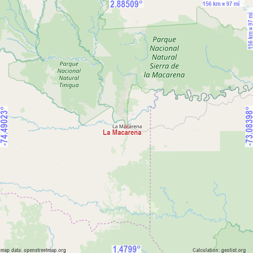
La Macarena GPS coordinates[2]
2° 10' 57.576" North, 73° 47' 13.56" West
| Map corner | latitude | longitude |
|---|---|---|
| Upper-left | 2.88509°, | -74.49023° |
| Center: | 2.18266°, | -73.7871° |
| Lower-right: | 1.4799°, | -73.08398° |
| Map W x H: | 156.2×156.2 km | = 97.1×97.1mi |
| max Lat: | 13.38166° ⇑89% North |
| La Macarena: | 2.18266° |
| min Lat: | ⇓11% South -4.21528° |
| min Long | La Macarena | max Long |
| -81.70636° | -73.7871° | -67.06996° |
| W 70.3%⇐ | ⇒29.7% E |
Elevation
Elevation of La Macarena is 229 m = 751 ft, and this is 920.3 m = 3019 ft below average elevation for this country.
| Max E: |
3342 m = 10965 ft | 73.1% |
| Avg. | 1149.3 m = 3771 ft | |
| La Macarena | 229 m = 751 ft | |
Min E: |
1 m = 3 ft | 26.9% |
See also: Colombia elevation on elevation.city.
Geographical zone
La Macarena is located in North Torrid zone (between Equator and Tropic of Cancer). Distance of Equator is 242.7 km =150.8 mi to South.| Distance of | km | miles | from La Macarena |
|---|---|---|---|
| North Pole | 9764.4 | 6067.3 | to North |
| Arctic Circle | 7158.5 | 4448.1 | to North |
| Tropic Cancer | 2363.2 | 1468.4 | to North |
| Equator | 242.7 | 150.8 | to South |


Nearby cities:
15 places around La Macarena: (largest is in red/bold)
• Calamar
128.4 km =79.8 mi,  101°
101°
• Cartagena del Chairá
150.5 km =93.5 mi,  231°
231°
• El Dorado
121.4 km =75.4 mi,  57°
57°
• El Retorno
129.9 km =80.7 mi,  82°
82°
• Fuente de Oro
143.5 km =89.2 mi,  7°
7°
• Mesetas
136.7 km =84.9 mi,  347°
347°
• Puerto Concordia
124.4 km =77.3 mi,  66°
66°
• Puerto Lleras
102.6 km =63.8 mi,  24°
24°
• Puerto Lleras
129.2 km =80.3 mi, 20°
• Puerto Yuca
105.8 km =65.7 mi,  37°
37°
• San José del Guaviare
134 km =83.3 mi, 71°
• San Juan de Arama
132.3 km =82.2 mi,  355°
355°
• San Vicente del Caguán
109 km =67.7 mi,  266°
266°
• Uribe
133.5 km =83 mi,  331°
331°
• Vistahermosa
104.8 km =65.1 mi,  2°
2°
Sources, notices
• [Note1] Compared only with cities in Colombia existing in our database
• [Src1] Map data: © OpenStreetMap contributors (CC-BY-SA)
• [Src2] Other city data from geonames.org with taken over terms of usage.
• [Src3] Geographical zone / Annual Mean Temperature by Robert A. Rohde @ Wikipedia
