Coyaima geodata
Coyaima (Tolima) is a seat of a second-order administrative division; located in Colombia in America/Bogota (GMT-5) time zone. With population of 3,893 people, there are 596 cities with bigger population in this country. Compared to other cities in Colombia, 79.6% of cities are located further ↑North; 59.3% of cities are located further →East and 67.1% of cities have higher elevation than Coyaima. Note1


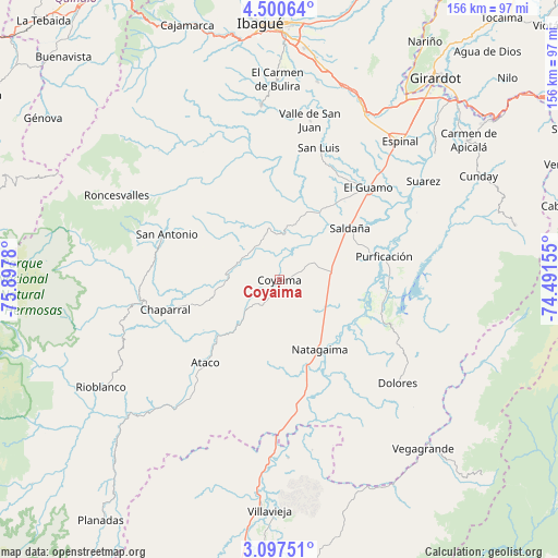
Coyaima GPS coordinates[2]
3° 47' 57.696" North, 75° 11' 40.812" West
| Map corner | latitude | longitude |
|---|---|---|
| Upper-left | 4.50064°, | -75.8978° |
| Center: | 3.79936°, | -75.19467° |
| Lower-right: | 3.09751°, | -74.49155° |
| Map W x H: | 156×156 km | = 96.9×96.9mi |
| max Lat: | 13.38166° ⇑79.6% North |
| Coyaima: | 3.79936° |
| min Lat: | ⇓20.4% South -4.21528° |
| min Long | Coyaima | max Long |
| -81.70636° | -75.19467° | -67.06996° |
| W 40.7%⇐ | ⇒59.3% E |
Elevation
Elevation of Coyaima is 359 m = 1178 ft, and this is 790.3 m = 2593 ft below average elevation for this country.
| Max E: |
3342 m = 10965 ft | 67.1% |
| Avg. | 1149.3 m = 3771 ft | |
| Coyaima | 359 m = 1178 ft | |
Min E: |
1 m = 3 ft | 32.9% |
See also: Colombia elevation on elevation.city.
Geographical zone
Coyaima is located in North Torrid zone (between Equator and Tropic of Cancer). Distance of Equator is 422.4 km =262.5 mi to South.| Distance of | km | miles | from Coyaima |
|---|---|---|---|
| North Pole | 9584.6 | 5955.6 | to North |
| Arctic Circle | 6978.7 | 4336.4 | to North |
| Tropic Cancer | 2183.5 | 1356.8 | to North |
| Equator | 422.4 | 262.5 | to South |


Nearby cities:
15 places around Coyaima: (largest is in red/bold)
• Ataco
31.1 km =19.3 mi,  221°
221°
• Chaparral
33.1 km =20.6 mi,  255°
255°
• Dolores
43.9 km =27.3 mi,  131°
131°
• Guamo
35.8 km =22.2 mi,  44°
44°
• La Chamba
44.1 km =27.4 mi,  55°
55°
• Natagaima
22.8 km =14.2 mi,  150°
150°
• Ortega
15.5 km =9.6 mi,  348°
348°
• Playarrica
37.3 km =23.2 mi,  320°
320°
• Prado
29.8 km =18.5 mi,  100°
100°
• Purificación
30 km =18.6 mi,  77°
77°
• Saldaña
24.6 km =15.3 mi,  54°
54°
• San Antonio
34.1 km =21.2 mi,  291°
291°
• San Luis
38.7 km =24 mi,  16°
16°
• Suárez
48.9 km =30.4 mi, 55°
• Valle de San Juan
45.2 km =28.1 mi,  10°
10°
Sources, notices
• [Note1] Compared only with cities in Colombia existing in our database
• [Src1] Map data: © OpenStreetMap contributors (CC-BY-SA)
• [Src2] Other city data from geonames.org with taken over terms of usage.
• [Src3] Geographical zone / Annual Mean Temperature by Robert A. Rohde @ Wikipedia
