Miraflores geodata
Miraflores (Guaviare) is a seat of a second-order administrative division; located in Colombia in America/Bogota (GMT-5) time zone. With population of 4,864 people, there are 520 cities with bigger population in this country. Compared to other cities in Colombia, 94.8% of cities are located further ↑North; 98% of cities are located further ←West and 74% of cities have higher elevation than Miraflores. Note1


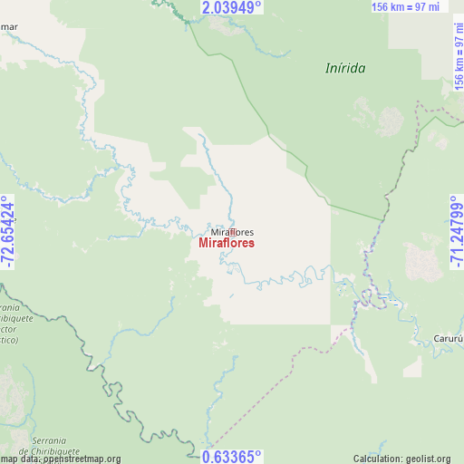
Miraflores GPS coordinates[2]
1° 20' 12.012" North, 71° 57' 3.996" West
| Map corner | latitude | longitude |
|---|---|---|
| Upper-left | 2.03949°, | -72.65424° |
| Center: | 1.33667°, | -71.95111° |
| Lower-right: | 0.63365°, | -71.24799° |
| Map W x H: | 156.3×156.3 km | = 97.1×97.1mi |
| max Lat: | 13.38166° ⇑94.8% North |
| Miraflores: | 1.33667° |
| min Lat: | ⇓5.2% South -4.21528° |
| min Long | Miraflores | max Long |
| -81.70636° | -71.95111° | -67.06996° |
| W 98%⇐ | ⇒2% E |
Elevation
Elevation of Miraflores is 209 m = 686 ft, and this is 940.3 m = 3085 ft below average elevation for this country.
| Max E: |
3342 m = 10965 ft | 74% |
| Avg. | 1149.3 m = 3771 ft | |
| Miraflores | 209 m = 686 ft | |
Min E: |
1 m = 3 ft | 26% |
See also: Colombia elevation on elevation.city.
Geographical zone
Miraflores is located in North Torrid zone (between Equator and Tropic of Cancer). Distance of Equator is 148.6 km =92.3 mi to South.| Distance of | km | miles | from Miraflores |
|---|---|---|---|
| North Pole | 9858.4 | 6125.7 | to North |
| Arctic Circle | 7252.6 | 4506.6 | to North |
| Tropic Cancer | 2457.3 | 1526.9 | to North |
| Equator | 148.6 | 92.3 | to South |


Nearby cities:
15 places around Miraflores: (largest is in red/bold)
• Calamar
104.3 km =64.8 mi,  311°
311°
• Carurú
81.2 km =50.5 mi,  116°
116°
• El Dorado
189.6 km =117.8 mi,  327°
327°
• El Retorno
133.6 km =83 mi, 325°
• Fuente de Oro
300.5 km =186.7 mi,  321°
321°
• La Macarena
224.7 km =139.6 mi,  294°
294°
• Mapiripán
174 km =108.1 mi,  353°
353°
• Mitú
191 km =118.7 mi,  92°
92°
• Puerto Concordia
168.7 km =104.8 mi, 327°
• Puerto Lleras
247.4 km =153.7 mi, 319°
• Puerto Lleras
266.9 km =165.8 mi, 323°
• Puerto Yuca
226.3 km =140.6 mi, 321°
• San Carlos de Guaroa
300.6 km =186.8 mi, 331°
• San José del Guaviare
157.7 km =98 mi, 330°
• Vistahermosa
282 km =175.2 mi, 314°
Sources, notices
• [Note1] Compared only with cities in Colombia existing in our database
• [Src1] Map data: © OpenStreetMap contributors (CC-BY-SA)
• [Src2] Other city data from geonames.org with taken over terms of usage.
• [Src3] Geographical zone / Annual Mean Temperature by Robert A. Rohde @ Wikipedia
