Guachetá geodata
Guachetá (Cundinamarca) is a seat of a second-order administrative division; located in Colombia in America/Bogota (GMT-5) time zone. With population of 4,245 people, there are 559 cities with bigger population in this country. Compared to other cities in Colombia, 52.9% of cities are located further ↑North; 71.8% of cities are located further ←West and 95.3% of cities have lower elevation than Guachetá. Note1


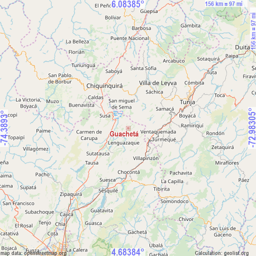
Guachetá GPS coordinates[2]
5° 23' 3.3" North, 73° 41' 10.212" West
| Map corner | latitude | longitude |
|---|---|---|
| Upper-left | 6.08385°, | -74.3893° |
| Center: | 5.38425°, | -73.68617° |
| Lower-right: | 4.68384°, | -72.98305° |
| Map W x H: | 155.7×155.7 km | = 96.7×96.7mi |
| max Lat: | 13.38166° ⇑52.9% North |
| Guachetá: | 5.38425° |
| min Lat: | ⇓47.1% South -4.21528° |
| min Long | Guachetá | max Long |
| -81.70636° | -73.68617° | -67.06996° |
| W 71.8%⇐ | ⇒28.2% E |
Elevation
Elevation of Guachetá is 2684 m = 8806 ft, and this is 1534.7 m = 5035 ft above average elevation for this country.
| Max E: |
3342 m = 10965 ft | 4.7% |
| Guachetá | 2684 m 8806 ft | |
| Avg. | 1149.3 m = 3771 ft | |
Min E: |
1 m = 3 ft | 95.3% |
See also: Colombia elevation on elevation.city.
Geographical zone
Guachetá is located in North Torrid zone (between Equator and Tropic of Cancer). Distance of Equator is 598.7 km =372 mi to South.| Distance of | km | miles | from Guachetá |
|---|---|---|---|
| North Pole | 9408.4 | 5846.1 | to North |
| Arctic Circle | 6802.5 | 4226.9 | to North |
| Tropic Cancer | 2007.2 | 1247.2 | to North |
| Equator | 598.7 | 372 | to South |


Nearby cities:
15 places around Guachetá: (largest is in red/bold)
• Carmen de Carupa
24.2 km =15 mi,  260°
260°
• Cucunubá
17.4 km =10.8 mi,  210°
210°
• Fúquene
12.4 km =7.7 mi,  280°
280°
• Lenguazaque
9 km =5.6 mi,  198°
198°
• Ráquira
18.1 km =11.2 mi,  19°
19°
• Samacá
25.3 km =15.7 mi,  61°
61°
• San Miguel de Sema
15.5 km =9.6 mi,  344°
344°
• Simijaca
22.6 km =14 mi,  305°
305°
• Susa
16.1 km =10 mi,  297°
297°
• Sutatausa
23.9 km =14.9 mi,  230°
230°
• Tinjacá
22.1 km =13.7 mi,  11°
11°
• Turmequé
22.7 km =14.1 mi,  107°
107°
• Ventaquemada
18.4 km =11.4 mi,  95°
95°
• Villa de San Diego de Ubaté
16.6 km =10.3 mi,  239°
239°
• Villapinzón
21.2 km =13.2 mi,  151°
151°
Sources, notices
• [Note1] Compared only with cities in Colombia existing in our database
• [Src1] Map data: © OpenStreetMap contributors (CC-BY-SA)
• [Src2] Other city data from geonames.org with taken over terms of usage.
• [Src3] Geographical zone / Annual Mean Temperature by Robert A. Rohde @ Wikipedia
