Valle de San Juan geodata
Valle de San Juan (Tolima) is a seat of a second-order administrative division; located in Colombia in America/Bogota (GMT-5) time zone. With population of 1,486 people, there are 868 cities with bigger population in this country. Compared to other cities in Colombia, 76.4% of cities are located further ↑North; 56.8% of cities are located further →East and 62.4% of cities have higher elevation than Valle de San Juan. Note1


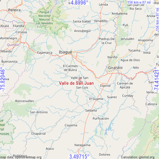
Valle de San Juan GPS coordinates[2]
4° 11' 55.284" North, 75° 7' 2.388" West
| Map corner | latitude | longitude |
|---|---|---|
| Upper-left | 4.8996°, | -75.82046° |
| Center: | 4.19869°, | -75.11733° |
| Lower-right: | 3.49715°, | -74.41421° |
| Map W x H: | 155.9×155.9 km | = 96.9×96.9mi |
| max Lat: | 13.38166° ⇑76.4% North |
| Valle de San Juan: | 4.19869° |
| min Lat: | ⇓23.6% South -4.21528° |
| min Long | Valle de San Ju | max Long |
| -81.70636° | -75.11733° | -67.06996° |
| W 43.2%⇐ | ⇒56.8% E |
Elevation
Elevation of Valle de San Juan is 588 m = 1929 ft, and this is 561.3 m = 1842 ft below average elevation for this country.
| Max E: |
3342 m = 10965 ft | 62.4% |
| Avg. | 1149.3 m = 3771 ft | |
| Valle de San Juan | 588 m = 1929 ft | |
Min E: |
1 m = 3 ft | 37.6% |
See also: Colombia elevation on elevation.city.
Geographical zone
Valle de San Juan is located in North Torrid zone (between Equator and Tropic of Cancer). Distance of Equator is 466.9 km =290.1 mi to South.| Distance of | km | miles | from Valle de San Juan |
|---|---|---|---|
| North Pole | 9540.2 | 5928 | to North |
| Arctic Circle | 6934.3 | 4308.8 | to North |
| Tropic Cancer | 2139.1 | 1329.2 | to North |
| Equator | 466.9 | 290.1 | to South |


Nearby cities:
15 places around Valle de San Juan: (largest is in red/bold)
• Chicoral
15.1 km =9.4 mi,  82°
82°
• Coello
26.3 km =16.3 mi,  67°
67°
• Coello
30 km =18.6 mi,  319°
319°
• Doima
29.9 km =18.6 mi,  31°
31°
• Espinal
26.4 km =16.4 mi,  102°
102°
• Flandes
34.9 km =21.7 mi, 73°
• Guamo
24.8 km =15.4 mi,  138°
138°
• Ibagué
29.6 km =18.4 mi,  334°
334°
• La Chamba
33.6 km =20.9 mi,  124°
124°
• Laureles
23.7 km =14.7 mi,  286°
286°
• Ortega
31.4 km =19.5 mi,  201°
201°
• Payandé
11.2 km =7 mi,  11°
11°
• Rovira
14.3 km =8.9 mi, 288°
• Saldaña
32 km =19.9 mi,  159°
159°
• San Luis
7.8 km =4.8 mi, 161°
Sources, notices
• [Note1] Compared only with cities in Colombia existing in our database
• [Src1] Map data: © OpenStreetMap contributors (CC-BY-SA)
• [Src2] Other city data from geonames.org with taken over terms of usage.
• [Src3] Geographical zone / Annual Mean Temperature by Robert A. Rohde @ Wikipedia
