Chicoral geodata
Chicoral (Tolima) is a populated place; located in Colombia in America/Bogota (GMT-5) time zone. With population of 14,686 people, there are 224 cities with bigger population in this country. Compared to other cities in Colombia, 75.9% of cities are located further ↑North; 53.9% of cities are located further →East and 66% of cities have higher elevation than Chicoral. Note1


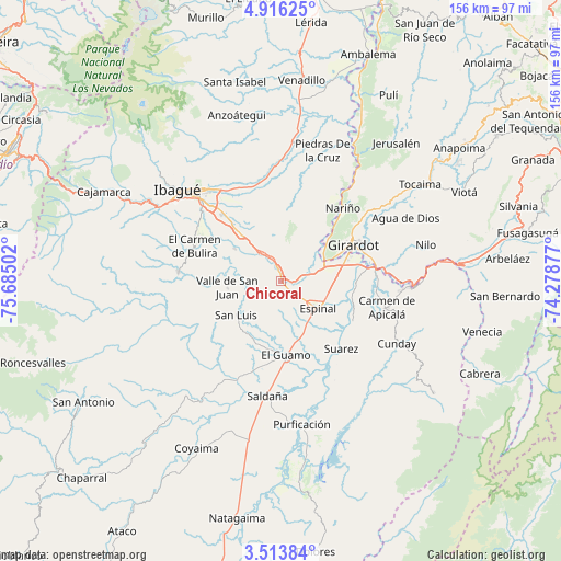
Chicoral GPS coordinates[2]
4° 12' 55.296" North, 74° 58' 54.804" West
| Map corner | latitude | longitude |
|---|---|---|
| Upper-left | 4.91625°, | -75.68502° |
| Center: | 4.21536°, | -74.98189° |
| Lower-right: | 3.51384°, | -74.27877° |
| Map W x H: | 155.9×155.9 km | = 96.9×96.9mi |
| max Lat: | 13.38166° ⇑75.9% North |
| Chicoral: | 4.21536° |
| min Lat: | ⇓24.1% South -4.21528° |
| min Long | Chicoral | max Long |
| -81.70636° | -74.98189° | -67.06996° |
| W 46.1%⇐ | ⇒53.9% E |
Elevation
Elevation of Chicoral is 409 m = 1342 ft, and this is 740.3 m = 2429 ft below average elevation for this country.
| Max E: |
3342 m = 10965 ft | 66% |
| Avg. | 1149.3 m = 3771 ft | |
| Chicoral | 409 m = 1342 ft | |
Min E: |
1 m = 3 ft | 34% |
See also: Colombia elevation on elevation.city.
Geographical zone
Chicoral is located in North Torrid zone (between Equator and Tropic of Cancer). Distance of Equator is 468.7 km =291.2 mi to South.| Distance of | km | miles | from Chicoral |
|---|---|---|---|
| North Pole | 9538.4 | 5926.9 | to North |
| Arctic Circle | 6932.5 | 4307.7 | to North |
| Tropic Cancer | 2137.2 | 1328 | to North |
| Equator | 468.7 | 291.2 | to South |


Nearby cities:
15 places around Chicoral: (largest is in red/bold)
• Carmen de Apicalá
30 km =18.6 mi,  104°
104°
• Coello
12.4 km =7.7 mi,  48°
48°
• Doima
23.5 km =14.6 mi,  1°
1°
• Espinal
13.1 km =8.1 mi,  124°
124°
• Flandes
20.2 km =12.6 mi,  65°
65°
• Girardot City
21.5 km =13.4 mi,  63°
63°
• Guamo
20.6 km =12.8 mi,  176°
176°
• La Chamba
24.5 km =15.2 mi,  149°
149°
• Nariño
26.6 km =16.5 mi,  40°
40°
• Payandé
15.7 km =9.8 mi,  305°
305°
• Ricaurte
25.2 km =15.7 mi, 73°
• Rovira
28.7 km =17.8 mi,  275°
275°
• San Luis
15.6 km =9.7 mi,  233°
233°
• Suárez
24.9 km =15.5 mi,  138°
138°
• Valle de San Juan
15.1 km =9.4 mi,  262°
262°
Sources, notices
• [Note1] Compared only with cities in Colombia existing in our database
• [Src1] Map data: © OpenStreetMap contributors (CC-BY-SA)
• [Src2] Other city data from geonames.org with taken over terms of usage.
• [Src3] Geographical zone / Annual Mean Temperature by Robert A. Rohde @ Wikipedia
