Prado geodata
Prado (Tolima) is a seat of a second-order administrative division; located in Colombia in America/Bogota (GMT-5) time zone. With population of 3,556 people, there are 624 cities with bigger population in this country. Compared to other cities in Colombia, 79.8% of cities are located further ↑North; 52.5% of cities are located further →East and 68.7% of cities have higher elevation than Prado. Note1


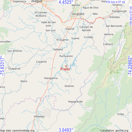
Prado GPS coordinates[2]
3° 45' 4.248" North, 74° 55' 48.144" West
| Map corner | latitude | longitude |
|---|---|---|
| Upper-left | 4.4525°, | -75.63317° |
| Center: | 3.75118°, | -74.93004° |
| Lower-right: | 3.0493°, | -74.22692° |
| Map W x H: | 156×156 km | = 96.9×96.9mi |
| max Lat: | 13.38166° ⇑79.8% North |
| Prado: | 3.75118° |
| min Lat: | ⇓20.2% South -4.21528° |
| min Long | Prado | max Long |
| -81.70636° | -74.93004° | -67.06996° |
| W 47.5%⇐ | ⇒52.5% E |
Elevation
Elevation of Prado is 322 m = 1056 ft, and this is 827.3 m = 2714 ft below average elevation for this country.
| Max E: |
3342 m = 10965 ft | 68.7% |
| Avg. | 1149.3 m = 3771 ft | |
| Prado | 322 m = 1056 ft | |
Min E: |
1 m = 3 ft | 31.3% |
See also: Colombia elevation on elevation.city.
Geographical zone
Prado is located in North Torrid zone (between Equator and Tropic of Cancer). Distance of Equator is 417.1 km =259.2 mi to South.| Distance of | km | miles | from Prado |
|---|---|---|---|
| North Pole | 9590 | 5958.9 | to North |
| Arctic Circle | 6984.1 | 4339.7 | to North |
| Tropic Cancer | 2188.8 | 1360.1 | to North |
| Equator | 417.1 | 259.2 | to South |


Nearby cities:
15 places around Prado: (largest is in red/bold)
• Alpujarra
40 km =24.9 mi,  180°
180°
• Colombia
44.1 km =27.4 mi,  161°
161°
• Coyaima
29.8 km =18.5 mi,  280°
280°
• Cunday
43.3 km =26.9 mi,  37°
37°
• Dolores
23.9 km =14.9 mi,  171°
171°
• Espinal
44.6 km =27.7 mi,  6°
6°
• Guamo
31.4 km =19.5 mi,  351°
351°
• La Chamba
31.4 km =19.5 mi, 12°
• Natagaima
23.3 km =14.5 mi,  231°
231°
• Ortega
38.3 km =23.8 mi,  302°
302°
• Purificación
12 km =7.5 mi,  359°
359°
• Saldaña
21.9 km =13.6 mi,  334°
334°
• Suárez
34.9 km =21.7 mi,  18°
18°
• Tres Esquinas
27.6 km =17.1 mi,  62°
62°
• Villarrica
41.9 km =26 mi, 60°
Sources, notices
• [Note1] Compared only with cities in Colombia existing in our database
• [Src1] Map data: © OpenStreetMap contributors (CC-BY-SA)
• [Src2] Other city data from geonames.org with taken over terms of usage.
• [Src3] Geographical zone / Annual Mean Temperature by Robert A. Rohde @ Wikipedia
