Juradó geodata
Juradó (Chocó) is a populated place; located in Colombia in America/Bogota (GMT-5) time zone. With population of 2,351 people, there are 759 cities with bigger population in this country. Compared to other cities in Colombia, 75.3% of cities are located further ↓South; 98.5% of cities are located further →East and 98.5% of cities have higher elevation than Juradó. Note1


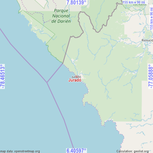
Juradó GPS coordinates[2]
7° 6' 15.156" North, 77° 45' 43.2" West
| Map corner | latitude | longitude |
|---|---|---|
| Upper-left | 7.80139°, | -78.46513° |
| Center: | 7.10421°, | -77.762° |
| Lower-right: | 6.40597°, | -77.05888° |
| Map W x H: | 155.2×155.2 km | = 96.4×96.4mi |
| max Lat: | 13.38166° ⇑24.7% North |
| Juradó: | 7.10421° |
| min Lat: | ⇓75.3% South -4.21528° |
| min Long | Juradó | max Long |
| -81.70636° | -77.762° | -67.06996° |
| W 1.5%⇐ | ⇒98.5% E |
Elevation
Elevation of Juradó is 6 m = 20 ft, and this is 1143.3 m = 3751 ft below average elevation for this country.
| Max E: |
3342 m = 10965 ft | 98.5% |
| Avg. | 1149.3 m = 3771 ft | |
| Juradó | 6 m = 20 ft | |
Min E: |
1 m = 3 ft | 1.5% |
See also: Colombia elevation on elevation.city.
Geographical zone
Juradó is located in North Torrid zone (between Equator and Tropic of Cancer). Distance of Equator is 789.9 km =490.8 mi to South.| Distance of | km | miles | from Juradó |
|---|---|---|---|
| North Pole | 9217.1 | 5727.2 | to North |
| Arctic Circle | 6611.3 | 4108.1 | to North |
| Tropic Cancer | 1816 | 1128.4 | to North |
| Equator | 789.9 | 490.8 | to South |


Nearby cities:
15 places around Juradó: (largest is in red/bold)
• Apartadó
152.3 km =94.6 mi,  55°
55°
• Bahía Solano
105.3 km =65.4 mi,  157°
157°
• Bellavista
114.5 km =71.1 mi,  122°
122°
• Beté
164.2 km =102 mi,  138°
138°
• Carepa
142.3 km =88.4 mi, 59°
• Chigorodó
134.6 km =83.6 mi, 62°
• Curbaradó
87.5 km =54.4 mi,  86°
86°
• Dabeiba
165.1 km =102.6 mi, 94°
• Murindó
104.7 km =65.1 mi,  97°
97°
• Mutatá
147.1 km =91.4 mi,  83°
83°
• Nuquí
164 km =101.9 mi, 160°
• Riosucio
80.3 km =49.9 mi, 61°
• Turbo
158.3 km =98.4 mi,  46°
46°
• Unguía
128 km =79.5 mi,  35°
35°
• Vigía del Fuerte
111.4 km =69.2 mi, 120°
Sources, notices
• [Note1] Compared only with cities in Colombia existing in our database
• [Src1] Map data: © OpenStreetMap contributors (CC-BY-SA)
• [Src2] Other city data from geonames.org with taken over terms of usage.
• [Src3] Geographical zone / Annual Mean Temperature by Robert A. Rohde @ Wikipedia
