Pocosol geodata
Pocosol (Alajuela) is a populated place; located in Costa Rica in America/Costa_Rica (GMT-6) time zone. With population of 2,947 people, there are 96 cities with bigger population in this country. Compared to other cities in Costa Rica, 88.8% of cities are located further ↓South; 79.1% of cities are located further →East and 64.2% of cities have higher elevation than Pocosol. Note1


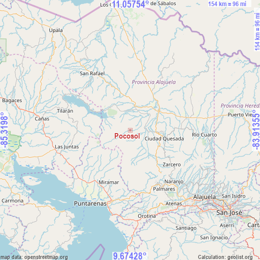
Pocosol GPS coordinates[2]
10° 22' 0.012" North, 84° 37' 0.012" West
| Map corner | latitude | longitude |
|---|---|---|
| Upper-left | 11.05754°, | -85.3198° |
| Center: | 10.36667°, | -84.61667° |
| Lower-right: | 9.67428°, | -83.91355° |
| Map W x H: | 153.8×153.8 km | = 95.6×95.6mi |
| max Lat: | 11.07377° ⇑11.2% North |
| Pocosol: | 10.36667° |
| min Lat: | ⇓88.8% South 8.53305° |
| min Long | Pocosol | max Long |
| -85.64748° | -84.61667° | -82.62185° |
| W 20.9%⇐ | ⇒79.1% E |
Elevation
Elevation of Pocosol is 370 m = 1214 ft, and this is 365 m = 1198 ft below average elevation for this country.
| Max E: |
1844 m = 6050 ft | 64.2% |
| Avg. | 735 m = 2411 ft | |
| Pocosol | 370 m = 1214 ft | |
Min E: |
7 m = 23 ft | 35.8% |
See also: Costa Rica elevation on elevation.city.
Geographical zone
Pocosol is located in North Torrid zone (between Equator and Tropic of Cancer). Distance of Equator is 1152.7 km =716.3 mi to South.| Distance of | km | miles | from Pocosol |
|---|---|---|---|
| North Pole | 8854.4 | 5501.9 | to North |
| Arctic Circle | 6248.5 | 3882.6 | to North |
| Tropic Cancer | 1453.3 | 903 | to North |
| Equator | 1152.7 | 716.3 | to South |


Nearby cities:
15 places around Pocosol: (largest is in red/bold)
• Esquipulas
40.4 km =25.1 mi,  148°
148°
• Florencia
15.5 km =9.6 mi,  92°
92°
• Juntas
38.7 km =24 mi,  255°
255°
• La Fortuna
12 km =7.5 mi,  344°
344°
• Laguna
29.4 km =18.3 mi,  126°
126°
• Macacona
40.6 km =25.2 mi,  183°
183°
• Miramar
32.9 km =20.4 mi,  202°
202°
• Naranjo
39.6 km =24.6 mi,  138°
138°
• Pital
38.6 km =24 mi,  76°
76°
• Quesada
21.3 km =13.2 mi,  102°
102°
• Río Segundo
39.4 km =24.5 mi,  110°
110°
• San Rafael
37.2 km =23.1 mi, 154°
• San Ramón
34.9 km =21.7 mi, 152°
• Tilarán
40 km =24.9 mi,  286°
286°
• Zarcero
31.9 km =19.8 mi, 129°
Sources, notices
• [Note1] Compared only with cities in Costa Rica existing in our database
• [Src1] Map data: © OpenStreetMap contributors (CC-BY-SA)
• [Src2] Other city data from geonames.org with taken over terms of usage.
• [Src3] Geographical zone / Annual Mean Temperature by Robert A. Rohde @ Wikipedia
