La Fortuna geodata
La Fortuna (Alajuela) is a populated place; located in Costa Rica in America/Costa_Rica (GMT-6) time zone. With population of 3,010 people, there are 95 cities with bigger population in this country. Compared to other cities in Costa Rica, 93.3% of cities are located further ↓South; 81.3% of cities are located further →East and 68.7% of cities have higher elevation than La Fortuna. Note1


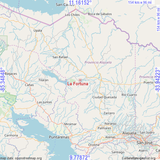
La Fortuna GPS coordinates[2]
10° 28' 15.204" North, 84° 38' 43.26" West
| Map corner | latitude | longitude |
|---|---|---|
| Upper-left | 11.16152°, | -85.34848° |
| Center: | 10.47089°, | -84.64535° |
| Lower-right: | 9.77872°, | -83.94223° |
| Map W x H: | 153.8×153.8 km | = 95.6×95.6mi |
| max Lat: | 11.07377° ⇑6.7% North |
| La Fortuna: | 10.47089° |
| min Lat: | ⇓93.3% South 8.53305° |
| min Long | La Fortuna | max Long |
| -85.64748° | -84.64535° | -82.62185° |
| W 18.7%⇐ | ⇒81.3% E |
Elevation
Elevation of La Fortuna is 256 m = 840 ft, and this is 479 m = 1572 ft below average elevation for this country.
| Max E: |
1844 m = 6050 ft | 68.7% |
| Avg. | 735 m = 2411 ft | |
| La Fortuna | 256 m = 840 ft | |
Min E: |
7 m = 23 ft | 31.3% |
See also: Costa Rica elevation on elevation.city.
Geographical zone
La Fortuna is located in North Torrid zone (between Equator and Tropic of Cancer). Distance of Equator is 1164.3 km =723.5 mi to South.| Distance of | km | miles | from La Fortuna |
|---|---|---|---|
| North Pole | 8842.8 | 5494.7 | to North |
| Arctic Circle | 6236.9 | 3875.4 | to North |
| Tropic Cancer | 1441.7 | 895.8 | to North |
| Equator | 1164.3 | 723.5 | to South |


Nearby cities:
15 places around La Fortuna: (largest is in red/bold)
• Cañas
49.7 km =30.9 mi,  264°
264°
• Esquipulas
52.1 km =32.4 mi,  152°
152°
• Florencia
22.3 km =13.9 mi,  123°
123°
• Juntas
40.3 km =25 mi,  238°
238°
• Laguna
39.5 km =24.5 mi,  137°
137°
• Miramar
43.1 km =26.8 mi,  192°
192°
• Naranjo
50.7 km =31.5 mi, 144°
• Pital
40.7 km =25.3 mi,  93°
93°
• Pocosol
12 km =7.5 mi,  164°
164°
• Quesada
28.9 km =18 mi, 124°
• Río Segundo
47.5 km =29.5 mi, 122°
• San Rafael
49 km =30.4 mi, 157°
• San Ramón
46.7 km =29 mi, 155°
• Tilarán
35.3 km =21.9 mi,  269°
269°
• Zarcero
42.2 km =26.2 mi, 138°
Sources, notices
• [Note1] Compared only with cities in Costa Rica existing in our database
• [Src1] Map data: © OpenStreetMap contributors (CC-BY-SA)
• [Src2] Other city data from geonames.org with taken over terms of usage.
• [Src3] Geographical zone / Annual Mean Temperature by Robert A. Rohde @ Wikipedia
