Tilarán geodata
Tilarán (Guanacaste) is a seat of a second-order administrative division; located in Costa Rica in America/Costa_Rica (GMT-6) time zone. With population of 7,301 people, there are 62 cities with bigger population in this country. Compared to other cities in Costa Rica, 92.5% of cities are located further ↓South; 87.3% of cities are located further →East and 60.4% of cities have higher elevation than Tilarán. Note1


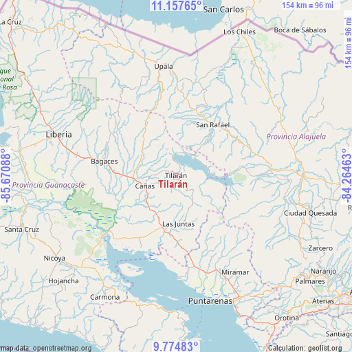
Tilarán GPS coordinates[2]
10° 28' 1.236" North, 84° 58' 3.9" West
| Map corner | latitude | longitude |
|---|---|---|
| Upper-left | 11.15765°, | -85.67088° |
| Center: | 10.46701°, | -84.96775° |
| Lower-right: | 9.77483°, | -84.26463° |
| Map W x H: | 153.8×153.8 km | = 95.6×95.6mi |
| max Lat: | 11.07377° ⇑7.5% North |
| Tilarán: | 10.46701° |
| min Lat: | ⇓92.5% South 8.53305° |
| min Long | Tilarán | max Long |
| -85.64748° | -84.96775° | -82.62185° |
| W 12.7%⇐ | ⇒87.3% E |
Elevation
Elevation of Tilarán is 545 m = 1788 ft, and this is 190 m = 623 ft below average elevation for this country.
| Max E: |
1844 m = 6050 ft | 60.4% |
| Avg. | 735 m = 2411 ft | |
| Tilarán | 545 m = 1788 ft | |
Min E: |
7 m = 23 ft | 39.6% |
See also: Costa Rica elevation on elevation.city.
Geographical zone
Tilarán is located in North Torrid zone (between Equator and Tropic of Cancer). Distance of Equator is 1163.8 km =723.2 mi to South.| Distance of | km | miles | from Tilarán |
|---|---|---|---|
| North Pole | 8843.2 | 5494.9 | to North |
| Arctic Circle | 6237.4 | 3875.7 | to North |
| Tropic Cancer | 1442.1 | 896.1 | to North |
| Equator | 1163.8 | 723.2 | to South |


Nearby cities:
15 places around Tilarán: (largest is in red/bold)
• Bagaces
32.1 km =19.9 mi,  281°
281°
• Bijagua
31.1 km =19.3 mi,  341°
341°
• Cañas
14.8 km =9.2 mi,  254°
254°
• Chacarita
57.5 km =35.7 mi,  158°
158°
• Florencia
55.2 km =34.3 mi,  102°
102°
• Fortuna
34.2 km =21.3 mi,  312°
312°
• Juntas
20.7 km =12.9 mi,  177°
177°
• La Fortuna
35.3 km =21.9 mi,  89°
89°
• Liberia
54.7 km =34 mi,  289°
289°
• Miramar
49.1 km =30.5 mi,  147°
147°
• Nandayure
54.5 km =33.9 mi,  207°
207°
• Pocosol
40 km =24.9 mi,  106°
106°
• Puntarenas
56.4 km =35 mi,  165°
165°
• San José
56.9 km =35.4 mi, 341°
• Upala
48.2 km =30 mi,  353°
353°
Sources, notices
• [Note1] Compared only with cities in Costa Rica existing in our database
• [Src1] Map data: © OpenStreetMap contributors (CC-BY-SA)
• [Src2] Other city data from geonames.org with taken over terms of usage.
• [Src3] Geographical zone / Annual Mean Temperature by Robert A. Rohde @ Wikipedia
