Fortuna geodata
Fortuna (Guanacaste) is a populated place; located in Costa Rica in America/Costa_Rica (GMT-6) time zone. With population of 1,774 people, there are 107 cities with bigger population in this country. Compared to other cities in Costa Rica, 96.3% of cities are located further ↓South; 91% of cities are located further →East and 61.9% of cities have higher elevation than Fortuna. Note1


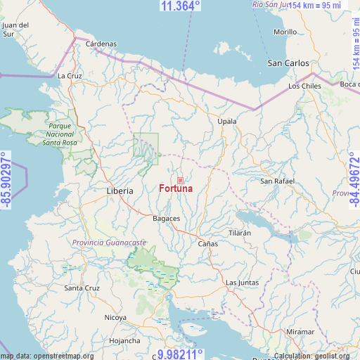
Fortuna GPS coordinates[2]
10° 40' 25.824" North, 85° 11' 59.424" West
| Map corner | latitude | longitude |
|---|---|---|
| Upper-left | 11.364°, | -85.90297° |
| Center: | 10.67384°, | -85.19984° |
| Lower-right: | 9.98211°, | -84.49672° |
| Map W x H: | 153.7×153.7 km | = 95.5×95.5mi |
| max Lat: | 11.07377° ⇑3.7% North |
| Fortuna: | 10.67384° |
| min Lat: | ⇓96.3% South 8.53305° |
| min Long | Fortuna | max Long |
| -85.64748° | -85.19984° | -82.62185° |
| W 9%⇐ | ⇒91% E |
Elevation
Elevation of Fortuna is 437 m = 1434 ft, and this is 298 m = 978 ft below average elevation for this country.
| Max E: |
1844 m = 6050 ft | 61.9% |
| Avg. | 735 m = 2411 ft | |
| Fortuna | 437 m = 1434 ft | |
Min E: |
7 m = 23 ft | 38.1% |
See also: Costa Rica elevation on elevation.city.
Geographical zone
Fortuna is located in North Torrid zone (between Equator and Tropic of Cancer). Distance of Equator is 1186.8 km =737.4 mi to South.| Distance of | km | miles | from Fortuna |
|---|---|---|---|
| North Pole | 8820.2 | 5480.6 | to North |
| Arctic Circle | 6214.4 | 3861.4 | to North |
| Tropic Cancer | 1419.1 | 881.8 | to North |
| Equator | 1186.8 | 737.4 | to South |


Nearby cities:
15 places around Fortuna: (largest is in red/bold)
• Bagaces
17.6 km =10.9 mi,  200°
200°
• Belén
51.8 km =32.2 mi,  235°
235°
• Bijagua
17 km =10.6 mi,  67°
67°
• Cañas
29.2 km =18.1 mi,  157°
157°
• Juntas
51 km =31.7 mi,  148°
148°
• La Cruz
64.9 km =40.3 mi,  313°
313°
• La Fortuna
64.7 km =40.2 mi,  110°
110°
• Liberia
26.3 km =16.3 mi,  260°
260°
• Los Chiles
66.2 km =41.1 mi,  52°
52°
• Nicoya
64.4 km =40 mi,  205°
205°
• San José
31.7 km =19.7 mi,  12°
12°
• Santa Cruz
62.3 km =38.7 mi,  222°
222°
• Sardinal
51.9 km =32.2 mi,  250°
250°
• Tilarán
34.2 km =21.3 mi,  132°
132°
• Upala
32.1 km =19.9 mi,  39°
39°
Sources, notices
• [Note1] Compared only with cities in Costa Rica existing in our database
• [Src1] Map data: © OpenStreetMap contributors (CC-BY-SA)
• [Src2] Other city data from geonames.org with taken over terms of usage.
• [Src3] Geographical zone / Annual Mean Temperature by Robert A. Rohde @ Wikipedia
