Mercedes geodata
Mercedes (San José) is a populated place; located in Costa Rica in America/Costa_Rica (GMT-6) time zone. With population of 5,467 people, there are 73 cities with bigger population in this country. Compared to other cities in Costa Rica, 94.8% of cities are located further ↑North; 89.6% of cities are located further ←West and 59.7% of cities have higher elevation than Mercedes. Note1


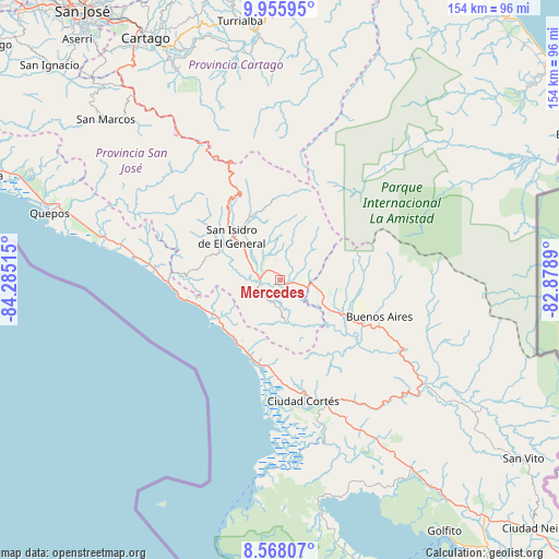
Mercedes GPS coordinates[2]
9° 15' 45.72" North, 83° 34' 55.272" West
| Map corner | latitude | longitude |
|---|---|---|
| Upper-left | 9.95595°, | -84.28515° |
| Center: | 9.2627°, | -83.58202° |
| Lower-right: | 8.56807°, | -82.8789° |
| Map W x H: | 154.3×154.3 km | = 95.9×95.9mi |
| max Lat: | 11.07377° ⇑94.8% North |
| Mercedes: | 9.2627° |
| min Lat: | ⇓5.2% South 8.53305° |
| min Long | Mercedes | max Long |
| -85.64748° | -83.58202° | -82.62185° |
| W 89.6%⇐ | ⇒10.4% E |
Elevation
Elevation of Mercedes is 597 m = 1959 ft, and this is 138 m = 453 ft below average elevation for this country.
| Max E: |
1844 m = 6050 ft | 59.7% |
| Avg. | 735 m = 2411 ft | |
| Mercedes | 597 m = 1959 ft | |
Min E: |
7 m = 23 ft | 40.3% |
See also: Costa Rica elevation on elevation.city.
Geographical zone
Mercedes is located in North Torrid zone (between Equator and Tropic of Cancer). Distance of Equator is 1029.9 km =639.9 mi to South.| Distance of | km | miles | from Mercedes |
|---|---|---|---|
| North Pole | 8977.1 | 5578.1 | to North |
| Arctic Circle | 6371.3 | 3958.9 | to North |
| Tropic Cancer | 1576 | 979.3 | to North |
| Equator | 1029.9 | 639.9 | to South |


Nearby cities:
15 places around Mercedes: (largest is in red/bold)
• Buenos Aires
29 km =18 mi,  110°
110°
• Capellades
76.6 km =47.6 mi,  343°
343°
• Cartago
76.5 km =47.5 mi,  331°
331°
• Ciudad Cortés
34.3 km =21.3 mi,  169°
169°
• Daniel Flores
12.6 km =7.8 mi,  310°
310°
• La Suiza
65.5 km =40.7 mi,  356°
356°
• Orosí
66.4 km =41.3 mi, 333°
• Paraíso
71.2 km =44.2 mi, 334°
• Pejibaye
62.4 km =38.8 mi,  347°
347°
• Quepos
66.3 km =41.2 mi,  286°
286°
• San Isidro
17.2 km =10.7 mi, 312°
• San Marcos
65.3 km =40.6 mi, 312°
• San Pablo
68.7 km =42.7 mi, 312°
• Tucurrique
67.5 km =41.9 mi, 346°
• Turrialba
72.2 km =44.9 mi, 351°
Sources, notices
• [Note1] Compared only with cities in Costa Rica existing in our database
• [Src1] Map data: © OpenStreetMap contributors (CC-BY-SA)
• [Src2] Other city data from geonames.org with taken over terms of usage.
• [Src3] Geographical zone / Annual Mean Temperature by Robert A. Rohde @ Wikipedia
