Ciudad Cortés geodata
Ciudad Cortés (Puntarenas) is a populated place; located in Costa Rica in America/Costa_Rica (GMT-6) time zone. With population of 3,850 people, there are 88 cities with bigger population in this country. Compared to other cities in Costa Rica, 96.3% of cities are located further ↑North; 90.3% of cities are located further ←West and 96.3% of cities have higher elevation than Ciudad Cortés. Note1


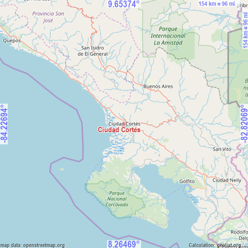
Ciudad Cortés GPS coordinates[2]
8° 57' 35.568" North, 83° 31' 25.716" West
| Map corner | latitude | longitude |
|---|---|---|
| Upper-left | 9.65374°, | -84.22694° |
| Center: | 8.95988°, | -83.52381° |
| Lower-right: | 8.26469°, | -82.82069° |
| Map W x H: | 154.4×154.5 km | = 95.9×96mi |
| max Lat: | 11.07377° ⇑96.3% North |
| Ciudad Cortés: | 8.95988° |
| min Lat: | ⇓3.7% South 8.53305° |
| min Long | Ciudad Cortés | max Long |
| -85.64748° | -83.52381° | -82.62185° |
| W 90.3%⇐ | ⇒9.7% E |
Elevation
Elevation of Ciudad Cortés is 10 m = 33 ft, and this is 725 m = 2379 ft below average elevation for this country.
| Max E: |
1844 m = 6050 ft | 96.3% |
| Avg. | 735 m = 2411 ft | |
| Ciudad Cortés | 10 m = 33 ft | |
Min E: |
7 m = 23 ft | 3.7% |
See also: Costa Rica elevation on elevation.city.
Geographical zone
Ciudad Cortés is located in North Torrid zone (between Equator and Tropic of Cancer). Distance of Equator is 996.2 km =619 mi to South.| Distance of | km | miles | from Ciudad Cortés |
|---|---|---|---|
| North Pole | 9010.8 | 5599 | to North |
| Arctic Circle | 6404.9 | 3979.8 | to North |
| Tropic Cancer | 1609.7 | 1000.2 | to North |
| Equator | 996.2 | 619 | to South |


Nearby cities:
15 places around Ciudad Cortés: (largest is in red/bold)
• Buenos Aires
31.5 km =19.6 mi,  41°
41°
• Canoas
89 km =55.3 mi,  122°
122°
• Corredor
72.8 km =45.2 mi, 119°
• Daniel Flores
44.7 km =27.8 mi,  339°
339°
• Golfito
60 km =37.3 mi,  131°
131°
• La Suiza
99.6 km =61.9 mi,  354°
354°
• Mercedes
34.3 km =21.3 mi, 349°
• Orosí
99.8 km =62 mi, 338°
• Pejibaye
96.7 km =60.1 mi, 348°
• Quepos
87.5 km =54.4 mi,  306°
306°
• Sabalito
69.3 km =43.1 mi,  103°
103°
• San Isidro
49.1 km =30.5 mi, 337°
• San Marcos
95 km =59 mi,  325°
325°
• San Pablo
98.4 km =61.1 mi,  324°
324°
• San Vito
62.7 km =39 mi, 104°
Sources, notices
• [Note1] Compared only with cities in Costa Rica existing in our database
• [Src1] Map data: © OpenStreetMap contributors (CC-BY-SA)
• [Src2] Other city data from geonames.org with taken over terms of usage.
• [Src3] Geographical zone / Annual Mean Temperature by Robert A. Rohde @ Wikipedia
