Buenos Aires geodata
Buenos Aires (Puntarenas) is a populated place; located in Costa Rica in America/Costa_Rica (GMT-6) time zone. With population of 11,680 people, there are 50 cities with bigger population in this country. Compared to other cities in Costa Rica, 95.5% of cities are located further ↑North; 92.5% of cities are located further ←West and 64.9% of cities have higher elevation than Buenos Aires. Note1


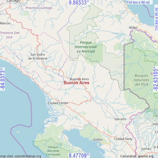
Buenos Aires GPS coordinates[2]
9° 10' 18.804" North, 83° 20' 3.012" West
| Map corner | latitude | longitude |
|---|---|---|
| Upper-left | 9.86533°, | -84.0373° |
| Center: | 9.17189°, | -83.33417° |
| Lower-right: | 8.47709°, | -82.63105° |
| Map W x H: | 154.4×154.4 km | = 95.9×95.9mi |
| max Lat: | 11.07377° ⇑95.5% North |
| Buenos Aires: | 9.17189° |
| min Lat: | ⇓4.5% South 8.53305° |
| min Long | Buenos Aires | max Long |
| -85.64748° | -83.33417° | -82.62185° |
| W 92.5%⇐ | ⇒7.5% E |
Elevation
Elevation of Buenos Aires is 361 m = 1184 ft, and this is 374 m = 1227 ft below average elevation for this country.
| Max E: |
1844 m = 6050 ft | 64.9% |
| Avg. | 735 m = 2411 ft | |
| Buenos Aires | 361 m = 1184 ft | |
Min E: |
7 m = 23 ft | 35.1% |
See also: Costa Rica elevation on elevation.city.
Geographical zone
Buenos Aires is located in North Torrid zone (between Equator and Tropic of Cancer). Distance of Equator is 1019.8 km =633.7 mi to South.| Distance of | km | miles | from Buenos Aires |
|---|---|---|---|
| North Pole | 8987.2 | 5584.4 | to North |
| Arctic Circle | 6381.4 | 3965.2 | to North |
| Tropic Cancer | 1586.1 | 985.6 | to North |
| Equator | 1019.8 | 633.7 | to South |


Nearby cities:
15 places around Buenos Aires: (largest is in red/bold)
• Cahuita
83 km =51.6 mi,  40°
40°
• Canoas
89.5 km =55.6 mi,  142°
142°
• Ciudad Cortés
31.5 km =19.6 mi,  221°
221°
• Corredor
72.9 km =45.3 mi, 144°
• Daniel Flores
41 km =25.5 mi,  296°
296°
• Golfito
67.7 km =42.1 mi,  159°
159°
• La Suiza
81.6 km =50.7 mi,  337°
337°
• Mercedes
29 km =18 mi,  290°
290°
• Orosí
89.8 km =55.8 mi,  320°
320°
• Pejibaye
81.8 km =50.8 mi,  330°
330°
• Sabalito
61 km =37.9 mi,  130°
130°
• San Isidro
45.4 km =28.2 mi, 298°
• San Vito
55.8 km =34.7 mi, 134°
• Sixaola
87.6 km =54.4 mi,  63°
63°
• Tucurrique
86.9 km =54 mi, 330°
Sources, notices
• [Note1] Compared only with cities in Costa Rica existing in our database
• [Src1] Map data: © OpenStreetMap contributors (CC-BY-SA)
• [Src2] Other city data from geonames.org with taken over terms of usage.
• [Src3] Geographical zone / Annual Mean Temperature by Robert A. Rohde @ Wikipedia
