Matina geodata
Matina (Limón) is a seat of a third-order administrative division; located in Costa Rica in America/Costa_Rica (GMT-6) time zone. With population of 2,315 people, there are 102 cities with bigger population in this country. Compared to other cities in Costa Rica, 71.6% of cities are located further ↓South; 94% of cities are located further ←West and 96.3% of cities have higher elevation than Matina. Note1


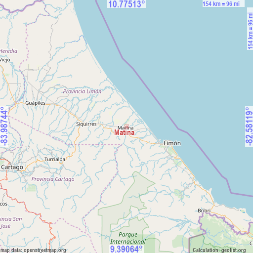
Matina GPS coordinates[2]
10° 5' 1.068" North, 83° 17' 3.516" West
| Map corner | latitude | longitude |
|---|---|---|
| Upper-left | 10.77513°, | -83.98744° |
| Center: | 10.08363°, | -83.28431° |
| Lower-right: | 9.39064°, | -82.58119° |
| Map W x H: | 153.9×153.9 km | = 95.6×95.6mi |
| max Lat: | 11.07377° ⇑28.4% North |
| Matina: | 10.08363° |
| min Lat: | ⇓71.6% South 8.53305° |
| min Long | Matina | max Long |
| -85.64748° | -83.28431° | -82.62185° |
| W 94%⇐ | ⇒6% E |
Elevation
Elevation of Matina is 10 m = 33 ft, and this is 725 m = 2379 ft below average elevation for this country.
| Max E: |
1844 m = 6050 ft | 96.3% |
| Avg. | 735 m = 2411 ft | |
| Matina | 10 m = 33 ft | |
Min E: |
7 m = 23 ft | 3.7% |
See also: Costa Rica elevation on elevation.city.
Geographical zone
Matina is located in North Torrid zone (between Equator and Tropic of Cancer). Distance of Equator is 1121.2 km =696.7 mi to South.| Distance of | km | miles | from Matina |
|---|---|---|---|
| North Pole | 8885.9 | 5521.4 | to North |
| Arctic Circle | 6280 | 3902.2 | to North |
| Tropic Cancer | 1484.7 | 922.5 | to North |
| Equator | 1121.2 | 696.7 | to South |


Nearby cities:
15 places around Matina: (largest is in red/bold)
• Batán
5.5 km =3.4 mi,  269°
269°
• Capellades
57.7 km =35.9 mi,  251°
251°
• Cariari
58.1 km =36.1 mi,  301°
301°
• Guácimo
46.5 km =28.9 mi,  288°
288°
• Guápiles
56.7 km =35.2 mi, 285°
• Jiménez
54.4 km =33.8 mi,  279°
279°
• La Suiza
44.7 km =27.8 mi,  234°
234°
• Limón
29.1 km =18.1 mi,  110°
110°
• Pacuarito
20.4 km =12.7 mi, 275°
• Pejibaye
55 km =34.2 mi,  236°
236°
• Pocora
36.4 km =22.6 mi, 285°
• Roxana
55 km =34.2 mi, 291°
• Siquirres
24.4 km =15.2 mi, 273°
• Tucurrique
54.4 km =33.8 mi, 241°
• Turrialba
48 km =29.8 mi, 245°
Sources, notices
• [Note1] Compared only with cities in Costa Rica existing in our database
• [Src1] Map data: © OpenStreetMap contributors (CC-BY-SA)
• [Src2] Other city data from geonames.org with taken over terms of usage.
• [Src3] Geographical zone / Annual Mean Temperature by Robert A. Rohde @ Wikipedia
