Cariari geodata
Cariari (Limón) is a seat of a third-order administrative division; located in Costa Rica in America/Costa_Rica (GMT-6) time zone. In our database, there are 124 cities with bigger population. Compared to other cities in Costa Rica, 87.3% of cities are located further ↓South; 82.8% of cities are located further ←West and 82.8% of cities have higher elevation than Cariari. Note1


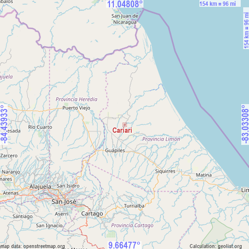
Cariari GPS coordinates[2]
10° 21' 25.884" North, 83° 44' 10.32" West
| Map corner | latitude | longitude |
|---|---|---|
| Upper-left | 11.04808°, | -84.43933° |
| Center: | 10.35719°, | -83.7362° |
| Lower-right: | 9.66477°, | -83.03308° |
| Map W x H: | 153.8×153.8 km | = 95.6×95.6mi |
| max Lat: | 11.07377° ⇑12.7% North |
| Cariari: | 10.35719° |
| min Lat: | ⇓87.3% South 8.53305° |
| min Long | Cariari | max Long |
| -85.64748° | -83.7362° | -82.62185° |
| W 82.8%⇐ | ⇒17.2% E |
Elevation
Elevation of Cariari is 65 m = 213 ft, and this is 670 m = 2198 ft below average elevation for this country.
| Max E: |
1844 m = 6050 ft | 82.8% |
| Avg. | 735 m = 2411 ft | |
| Cariari | 65 m = 213 ft | |
Min E: |
7 m = 23 ft | 17.2% |
See also: Costa Rica elevation on elevation.city.
Geographical zone
Cariari is located in North Torrid zone (between Equator and Tropic of Cancer). Distance of Equator is 1151.6 km =715.6 mi to South.| Distance of | km | miles | from Cariari |
|---|---|---|---|
| North Pole | 8855.5 | 5502.6 | to North |
| Arctic Circle | 6249.6 | 3883.3 | to North |
| Tropic Cancer | 1454.3 | 903.7 | to North |
| Equator | 1151.6 | 715.6 | to South |


Nearby cities:
15 places around Cariari: (largest is in red/bold)
• Batán
53.5 km =33.2 mi,  124°
124°
• Capellades
48.7 km =30.3 mi,  186°
186°
• Cot
53.6 km =33.3 mi,  196°
196°
• Dulce Nombre de Jesus
34.9 km =21.7 mi,  229°
229°
• Guácimo
16.9 km =10.5 mi,  161°
161°
• Guápiles
16.5 km =10.3 mi, 198°
• Ipís
52.9 km =32.9 mi,  214°
214°
• Jiménez
21.5 km =13.4 mi, 191°
• La Virgen
43.7 km =27.2 mi,  276°
276°
• Pacuarito
40.7 km =25.3 mi,  134°
134°
• Pocora
25.2 km =15.7 mi,  145°
145°
• Roxana
10.1 km =6.3 mi, 189°
• Siquirres
38.3 km =23.8 mi,  138°
138°
• Turrialba
50.6 km =31.4 mi,  173°
173°
• Ángeles
52.9 km =32.9 mi,  220°
220°
Sources, notices
• [Note1] Compared only with cities in Costa Rica existing in our database
• [Src1] Map data: © OpenStreetMap contributors (CC-BY-SA)
• [Src2] Other city data from geonames.org with taken over terms of usage.
• [Src3] Geographical zone / Annual Mean Temperature by Robert A. Rohde @ Wikipedia
