Batán geodata
Batán (Limón) is a seat of a fourth-order administrative division; located in Costa Rica in America/Costa_Rica (GMT-6) time zone. With population of 4,584 people, there are 76 cities with bigger population in this country. Compared to other cities in Costa Rica, 70.9% of cities are located further ↓South; 93.3% of cities are located further ←West and 91.8% of cities have higher elevation than Batán. Note1


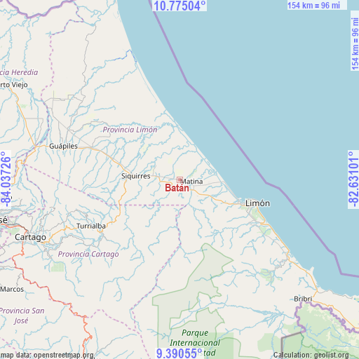
Batán GPS coordinates[2]
10° 5' 0.744" North, 83° 20' 2.868" West
| Map corner | latitude | longitude |
|---|---|---|
| Upper-left | 10.77504°, | -84.03726° |
| Center: | 10.08354°, | -83.33413° |
| Lower-right: | 9.39055°, | -82.63101° |
| Map W x H: | 153.9×153.9 km | = 95.6×95.6mi |
| max Lat: | 11.07377° ⇑29.1% North |
| Batán: | 10.08354° |
| min Lat: | ⇓70.9% South 8.53305° |
| min Long | Batán | max Long |
| -85.64748° | -83.33413° | -82.62185° |
| W 93.3%⇐ | ⇒6.7% E |
Elevation
Elevation of Batán is 18 m = 59 ft, and this is 717 m = 2352 ft below average elevation for this country.
| Max E: |
1844 m = 6050 ft | 91.8% |
| Avg. | 735 m = 2411 ft | |
| Batán | 18 m = 59 ft | |
Min E: |
7 m = 23 ft | 8.2% |
See also: Costa Rica elevation on elevation.city.
Geographical zone
Batán is located in North Torrid zone (between Equator and Tropic of Cancer). Distance of Equator is 1121.2 km =696.7 mi to South.| Distance of | km | miles | from Batán |
|---|---|---|---|
| North Pole | 8885.9 | 5521.4 | to North |
| Arctic Circle | 6280 | 3902.2 | to North |
| Tropic Cancer | 1484.7 | 922.5 | to North |
| Equator | 1121.2 | 696.7 | to South |


Nearby cities:
15 places around Batán: (largest is in red/bold)
• Capellades
52.6 km =32.7 mi,  249°
249°
• Cariari
53.5 km =33.2 mi,  304°
304°
• Guácimo
41.3 km =25.7 mi,  290°
290°
• Guápiles
51.5 km =32 mi, 286°
• Jiménez
49 km =30.4 mi,  281°
281°
• La Suiza
40.4 km =25.1 mi,  230°
230°
• Limón
34.2 km =21.3 mi,  107°
107°
• Matina
5.5 km =3.4 mi,  89°
89°
• Pacuarito
15 km =9.3 mi, 277°
• Pejibaye
50.5 km =31.4 mi, 233°
• Pocora
31.2 km =19.4 mi, 288°
• Roxana
50 km =31.1 mi, 294°
• Siquirres
18.9 km =11.7 mi,  274°
274°
• Tucurrique
49.7 km =30.9 mi,  238°
238°
• Turrialba
43.1 km =26.8 mi, 242°
Sources, notices
• [Note1] Compared only with cities in Costa Rica existing in our database
• [Src1] Map data: © OpenStreetMap contributors (CC-BY-SA)
• [Src2] Other city data from geonames.org with taken over terms of usage.
• [Src3] Geographical zone / Annual Mean Temperature by Robert A. Rohde @ Wikipedia
